IMAGES TAKEN NEAR TO
Green Street, SUNBURY-ON-THAMES, TW16 6QL
Introduction
This page details the photographs taken nearby to Green Street, TW16 6QL by members of the Geograph project.
The Geograph project started in 2005 with the aim of publishing, organising and preserving representative images for every square kilometre of Great Britain, Ireland and the Isle of Man.

There are currently over 7.5m images from over14,400 individuals and you can help contribute to the project by visiting https://www.geograph.org.uk
Image Map
Images are licensed for reuse under creativecommons.org/licenses/by-sa/2.0
Notes
- Clicking on the map will re-center to the selected point.
- The higher the marker number, the further away the image location is from the centre of the postcode.
Image Listing (63 Images Found)
Images are licensed for reuse under creativecommons.org/licenses/by-sa/2.0
Image
Details
Distance
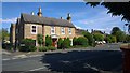
1
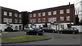
Sunmead Road - Townhouses
Three storey terrace houses.
Image: © James Emmans
Taken: 20 Mar 2016
0.03 miles
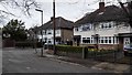
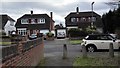
2
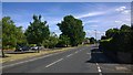
Green Street
Tree lined street with detached houses.
Image: © James Emmans
Taken: 7 Jun 2015
0.04 miles
3
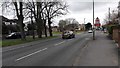
Green Street - Sunbury on Thames
Looking south towards Vereker Drive.
Image: © James Emmans
Taken: 20 Mar 2016
0.04 miles
5
Parkwood Grove off Croysdale Avenue
Small side road cul de sac.
Image: © James Emmans
Taken: 20 Mar 2016
0.08 miles
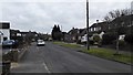
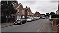
7
Croysdale Avenue
T Junction on Green Street
Image: © James Emmans
Taken: 7 Jun 2015
0.09 miles
9
Footpath between Maryland Way and Manor Lane
Houses on Maryland Way
Image: © James Emmans
Taken: 21 Feb 2016
0.10 miles
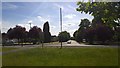
10
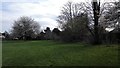
Cedars Recreational Grounds - Sunbury
Houses surround most of the recreation ground.
Image: © James Emmans
Taken: 14 Apr 2016
0.11 miles