IMAGES TAKEN NEAR TO
Nursery Road, SUNBURY-ON-THAMES, TW16 6LN
Introduction
This page details the photographs taken nearby to Nursery Road, TW16 6LN by members of the Geograph project.
The Geograph project started in 2005 with the aim of publishing, organising and preserving representative images for every square kilometre of Great Britain, Ireland and the Isle of Man.

There are currently over 7.5m images from over14,400 individuals and you can help contribute to the project by visiting https://www.geograph.org.uk
Image Map
Images are licensed for reuse under creativecommons.org/licenses/by-sa/2.0
Notes
- Clicking on the map will re-center to the selected point.
- The higher the marker number, the further away the image location is from the centre of the postcode.
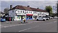
Image Listing (47 Images Found)
Images are licensed for reuse under creativecommons.org/licenses/by-sa/2.0
Image
Details
Distance
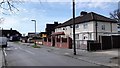
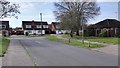
1
Nursery Road close to Stratton Road
A busy road in Sunbury towards the Upper Halliford Road.
Image: © James Emmans
Taken: 8 Apr 2020
0.02 miles

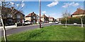
5
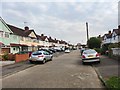
Evelyn Crescent
View north from close to Nursery Road.
Image: © James Emmans
Taken: 8 Apr 2020
0.06 miles
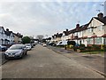
6
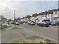
Beverley Road
View south 1950's semi-detached housing.
Image: © James Emmans
Taken: 8 Apr 2020
0.07 miles