IMAGES TAKEN NEAR TO
Nursery Road, SUNBURY-ON-THAMES, TW16 6LF
Introduction
This page details the photographs taken nearby to Nursery Road, TW16 6LF by members of the Geograph project.
The Geograph project started in 2005 with the aim of publishing, organising and preserving representative images for every square kilometre of Great Britain, Ireland and the Isle of Man.

There are currently over 7.5m images from over14,400 individuals and you can help contribute to the project by visiting https://www.geograph.org.uk
Image Map
Images are licensed for reuse under creativecommons.org/licenses/by-sa/2.0
Notes
- Clicking on the map will re-center to the selected point.
- The higher the marker number, the further away the image location is from the centre of the postcode.
Image Listing (50 Images Found)
Images are licensed for reuse under creativecommons.org/licenses/by-sa/2.0
Image
Details
Distance
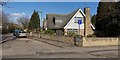
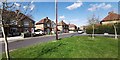
1
Alms Houses at the end of Ravens Court
Corner stone plaque says 'Erected by John Philip of Darby Lodge 1891'.
Image: © James Emmans
Taken: 7 Apr 2020
0.03 miles
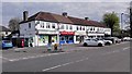
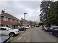
5
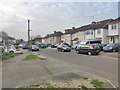
Beverley Road
View south 1950's semi-detached housing.
Image: © James Emmans
Taken: 8 Apr 2020
0.09 miles
7
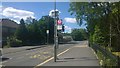
Bus Stop Green Street
The Chubb Tower can be seen on the horizon.
Image: © James Emmans
Taken: 7 Jun 2015
0.11 miles
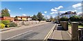
8
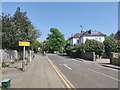
Nursery Road Traffic Lights
Nursery Road junction with Green Street.
Image: © James Emmans
Taken: 24 Apr 2020
0.11 miles
10
End of Nursery Road
Towards traffic light junction with Green Street.
Image: © James Emmans
Taken: 26 Mar 2019
0.12 miles