IMAGES TAKEN NEAR TO
Montford Road, SUNBURY-ON-THAMES, TW16 6EJ
Introduction
This page details the photographs taken nearby to Montford Road, TW16 6EJ by members of the Geograph project.
The Geograph project started in 2005 with the aim of publishing, organising and preserving representative images for every square kilometre of Great Britain, Ireland and the Isle of Man.

There are currently over 7.5m images from over14,400 individuals and you can help contribute to the project by visiting https://www.geograph.org.uk
Image Map
Images are licensed for reuse under creativecommons.org/licenses/by-sa/2.0
Notes
- Clicking on the map will re-center to the selected point.
- The higher the marker number, the further away the image location is from the centre of the postcode.
Image Listing (191 Images Found)
Images are licensed for reuse under creativecommons.org/licenses/by-sa/2.0
Image
Details
Distance
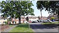
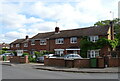
3
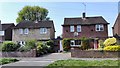
Montford Road - Sunbury
Detached houses close to town centre.
Image: © James Emmans
Taken: 7 May 2016
0.06 miles
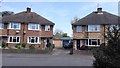
7
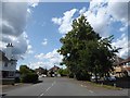
Looking west-northwest in Halliford Road
Image: © Basher Eyre
Taken: 13 Aug 2019
0.09 miles
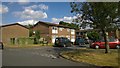
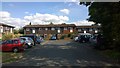
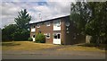
8
Flats
New development on the Environment Agency site which has improved the area.
Image: © James Emmans
Taken: 27 Jun 2015
0.10 miles
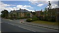
10
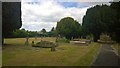
Anvil Road Burial Ground
Smaller cemetery.
Image: © James Emmans
Taken: 21 Jun 2015
0.10 miles