IMAGES TAKEN NEAR TO
Fordbridge Road, SUNBURY-ON-THAMES, TW16 6AP
Introduction
This page details the photographs taken nearby to Fordbridge Road, TW16 6AP by members of the Geograph project.
The Geograph project started in 2005 with the aim of publishing, organising and preserving representative images for every square kilometre of Great Britain, Ireland and the Isle of Man.

There are currently over 7.5m images from over14,400 individuals and you can help contribute to the project by visiting https://www.geograph.org.uk
Image Map
Images are licensed for reuse under creativecommons.org/licenses/by-sa/2.0
Notes
- Clicking on the map will re-center to the selected point.
- The higher the marker number, the further away the image location is from the centre of the postcode.
Image Listing (77 Images Found)
Images are licensed for reuse under creativecommons.org/licenses/by-sa/2.0
Image
Details
Distance
1
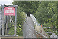
Footbridge from Wheatley's Ait
This bridge runs parallel to the road bridge and is not for public use.
Image: © David Kemp
Taken: 30 Jul 2009
0.04 miles
2
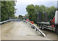
Bridge to Wheatley's Ait
The bridge runs from the Riverside Works of the Environment Agency in Fordbridge Road, Sunbury to the small industrial area on Wheatley's Ait. It is not open to the public.
Image: © David Kemp
Taken: 30 Jul 2009
0.04 miles
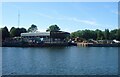
3
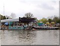
Covered dock on Wheatley's Ait
Seen from the Surrey bank, downstream from Walton. Much of Wheatley's Ait seems rather suburban - little properties along the river bank, each with its mooring for a small cabin cruiser. However, about half way along there is this industrial site, apparently a boat repair yard, with a covered dock.
Moored by the dock on this occasion was the tug 'Falconbrook'.
Image: © Stefan Czapski
Taken: 2 May 2012
0.06 miles
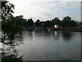
4
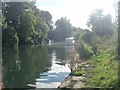
River Thames backwater at Sunbury
A short length of bank is accessible here in an area of public open space which includes a car park and children's play area
Image: © David Leeming
Taken: 26 Sep 2013
0.06 miles
5

Covered dock on the Thames at Sunbury
Part of an Environment Agency maintenance depot.
Image: © Rod Allday
Taken: 23 Jun 2011
0.07 miles
6

Industrial yard, Wheatley's Eyot
AN industrial area on Wheatley's Eyot in the Thames near Sunbury.
Image: © Alan Hunt
Taken: 20 Oct 2015
0.07 miles
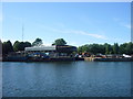
7
Boatyard at Wheatley's Eyot
Boatbuilders and works at Wheatley's Eyot taken from the Thames Path at Walton-on-Thames. This is on the route of the London Green Belt Way.
Image: © Sean Davis
Taken: 30 Jul 2008
0.07 miles
8
Boatyard on the Thames at Sunbury
A view across the river from the Thames Path.
Image: © Eirian Evans
Taken: 13 Oct 2011
0.07 miles
9
Boatyards on Wheatley's Ait
Wheatley's Ait is owned by the Environment Agency. It is joined to the north bank of the river by both foot and road bridges. There are a few boatyards and some houses on the island and there are plans to redevelop it and make a foot crossing of the river here.
Image: © Sean Davis
Taken: 30 Jul 2008
0.07 miles
10

Chalets beside the River Thames
Chalets on an eyot beside the River Thames upstream from Sunbury Lock.
Image: © Philip Halling
Taken: 3 Sep 2011
0.07 miles