IMAGES TAKEN NEAR TO
Fordbridge Road, SUNBURY-ON-THAMES, TW16 6AN
Introduction
This page details the photographs taken nearby to Fordbridge Road, TW16 6AN by members of the Geograph project.
The Geograph project started in 2005 with the aim of publishing, organising and preserving representative images for every square kilometre of Great Britain, Ireland and the Isle of Man.

There are currently over 7.5m images from over14,400 individuals and you can help contribute to the project by visiting https://www.geograph.org.uk
Image Map
Images are licensed for reuse under creativecommons.org/licenses/by-sa/2.0
Notes
- Clicking on the map will re-center to the selected point.
- The higher the marker number, the further away the image location is from the centre of the postcode.
Image Listing (92 Images Found)
Images are licensed for reuse under creativecommons.org/licenses/by-sa/2.0
Image
Details
Distance
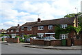
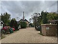
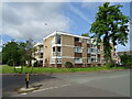
1
Fordbridge Road
Junction with Loudwater Close.
Image: © James Emmans
Taken: 10 Apr 2020
0.02 miles
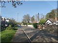
2
Loudwater Close
Short residential road to the south of Sunbury-on-Thames.
Image: © James Emmans
Taken: 31 Oct 2020
0.04 miles
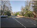
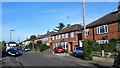
3
Fordbridge Road near the Car Park
Fordbridge Road runs parallel with the River Thames. There are plans to build a bridge close by here for cyclists and walkers.
Image: © James Emmans
Taken: 10 Apr 2020
0.06 miles
5
Fordbridge Road towards Thames Street
The road runs towards Lower Sunbury.
Image: © James Emmans
Taken: 10 Apr 2020
0.07 miles
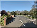
7
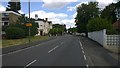
Fordbridge Road
Main road that follows the River Thames
Image: © James Emmans
Taken: 27 Jun 2015
0.09 miles
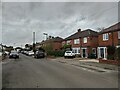
9
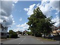
Looking west-northwest in Halliford Road
Image: © Basher Eyre
Taken: 13 Aug 2019
0.10 miles