IMAGES TAKEN NEAR TO
Lower Hampton Road, SUNBURY-ON-THAMES, TW16 5PH
Introduction
This page details the photographs taken nearby to Lower Hampton Road, TW16 5PH by members of the Geograph project.
The Geograph project started in 2005 with the aim of publishing, organising and preserving representative images for every square kilometre of Great Britain, Ireland and the Isle of Man.

There are currently over 7.5m images from over14,400 individuals and you can help contribute to the project by visiting https://www.geograph.org.uk
Image Map
Images are licensed for reuse under creativecommons.org/licenses/by-sa/2.0
Notes
- Clicking on the map will re-center to the selected point.
- The higher the marker number, the further away the image location is from the centre of the postcode.
Image Listing (96 Images Found)
Images are licensed for reuse under creativecommons.org/licenses/by-sa/2.0
Image
Details
Distance
1
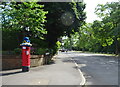
Lower Hampton Road
Showing position of Postbox No. TW16 246.
See Image] for postbox.
Image: © JThomas
Taken: 27 May 2022
0.01 miles

3
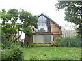
Modern house on the corner of Darby Crescent and Lower Hampton Road
Image: © David Howard
Taken: 22 Oct 2012
0.02 miles
4
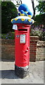
Yarn bombed George VI postbox on Lower Hampton Road
Postbox No. TW16 246.
See Image] for context.
Image: © JThomas
Taken: 27 May 2022
0.02 miles

6
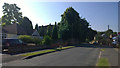
Darby Crescent
The Original Darby House can be seen poking about the trees. Originally I would be standing on the front lawn with George Darby gardeners keeping up appearances.
https://en.wikipedia.org/wiki/George_Darby
Image: © James Emmans
Taken: 21 Jun 2014
0.05 miles
7
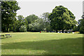
Rivermead Island
This is one of the few islands in the Thames to which there is public access. The trees in the farthest distance indicate the so-called Swan's Rest Island which was once an island in its own right but is now the eastern end of Rivermead Island.
Image: © David Kemp
Taken: 9 Jul 2009
0.06 miles
8
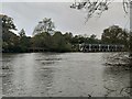
Reservoir Inlet
Water from the River Thames flows down an aqueduct to be pumped up into Bessborough and Knight reservoirs.
Image: © James Emmans
Taken: 30 Oct 2020
0.07 miles
9
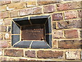
Plate showing the floodmark in 1894
Where the River Thames flooded Lower Hampton Road, Sunbury-on-Thames
Image: © Maggie Cox
Taken: 29 Jun 2013
0.07 miles
10
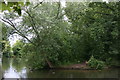
Swan's Rest
Although it was once an island in its own right and some local people still refer to it as such, Swan's Rest is in effect the wooded, downstream end of Rivermead Island.
Image: © David Kemp
Taken: 9 Jul 2009
0.07 miles