IMAGES TAKEN NEAR TO
Sunbury Court Road, SUNBURY-ON-THAMES, TW16 5NL
Introduction
This page details the photographs taken nearby to Sunbury Court Road, TW16 5NL by members of the Geograph project.
The Geograph project started in 2005 with the aim of publishing, organising and preserving representative images for every square kilometre of Great Britain, Ireland and the Isle of Man.

There are currently over 7.5m images from over14,400 individuals and you can help contribute to the project by visiting https://www.geograph.org.uk
Image Map
Images are licensed for reuse under creativecommons.org/licenses/by-sa/2.0
Notes
- Clicking on the map will re-center to the selected point.
- The higher the marker number, the further away the image location is from the centre of the postcode.
Image Listing (63 Images Found)
Images are licensed for reuse under creativecommons.org/licenses/by-sa/2.0
Image
Details
Distance
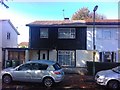
1
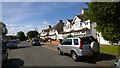
Sunbury Court Road
Residential road leading to Staines Road East
Image: © James Emmans
Taken: 6 Jun 2014
0.02 miles
2
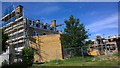
The George Pub turns into Homes
The big original Sunbury house 1769 is being developed into 4 flats.
Image: © James Emmans
Taken: 6 Jun 2014
0.05 miles
3
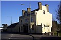
Former pub 'The George'
Another pub bites the dust, a notice on the door indicated it would be converted to flats. In 2004 the pub had a user rating of 5.2 out of 10, http://www.beerintheevening.com/pubs/s/84/8485/George/Sunbury
Image: © peter clayton
Taken: 7 Mar 2010
0.05 miles
4

Residential Development
Pub being converted into flats.
Image: © James Emmans
Taken: 25 Jun 2014
0.05 miles
5
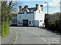
The Old George, Sunbury-on-Thames
This building was formerly The George Public House, 244 Staines Road East. It has been converted into apartments and now carries the name "The Old George" overv the doorway.
Image: © David Dixon
Taken: 11 Apr 2015
0.05 miles
6
Prefabricated Post War Semi-Detached House
BISF House - http://en.wikipedia.org/wiki/BISF_house
The walls are steel frame clad in stonework on ground floor and originally pressed metal sheet on the first floor. Built in 1946 after WWII when they were needed because of the bombing raids.
A house was built on spare land in this street that used the current building code but is an exact match to the original; that seems a lot of effort but the road is an important part of history and building a new style house would spoil this road.
The original asbestos sheet roof will eventually be changed to match most houses in the street but I noticed some people have managed to replace the roof in the old style somehow, they must understand the importance of the history to do that. All the old windows have now been replaced with modern plastic, which is needed in these cold poorly insulated houses, replacing with metal originals would be asking too much and cost too much.
Image: © James Emmans
Taken: 2 Oct 2011
0.06 miles
7
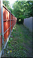
The Markway
Footpath leading to main road.
Image: © James Emmans
Taken: 6 Jun 2014
0.07 miles
8

A308 follows the curved southern boundary of Kempton Park
On the right is the Kempton park racecourse once a large manor estate of 360 acres. https://en.wikipedia.org/wiki/Kempton_Park,_Surrey
Image: © James Emmans
Taken: 25 Jun 2014
0.08 miles
9
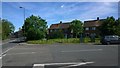
T Junction on Staines Road East with French Street
Post war council houses.
Image: © James Emmans
Taken: 6 Jun 2014
0.09 miles
10
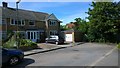
End of the Road
A new house seems to be added to the end.
Image: © James Emmans
Taken: 6 Jun 2014
0.10 miles