IMAGES TAKEN NEAR TO
Allen Road, SUNBURY-ON-THAMES, TW16 5LS
Introduction
This page details the photographs taken nearby to Allen Road, TW16 5LS by members of the Geograph project.
The Geograph project started in 2005 with the aim of publishing, organising and preserving representative images for every square kilometre of Great Britain, Ireland and the Isle of Man.

There are currently over 7.5m images from over14,400 individuals and you can help contribute to the project by visiting https://www.geograph.org.uk
Image Map
Images are licensed for reuse under creativecommons.org/licenses/by-sa/2.0
Notes
- Clicking on the map will re-center to the selected point.
- The higher the marker number, the further away the image location is from the centre of the postcode.
Image Listing (69 Images Found)
Images are licensed for reuse under creativecommons.org/licenses/by-sa/2.0
Image
Details
Distance
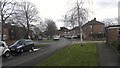
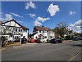
2
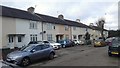
Allen Close off Allen Road
Small cul de sac with post war housing.
Image: © James Emmans
Taken: 21 Feb 2016
0.05 miles
4
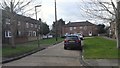
Looking north-northwest along Claremont Avenue
Image: © Basher Eyre
Taken: 21 Jan 2019
0.06 miles
6
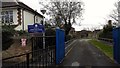
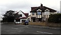
Entrance to Chennestone School
Primary school
http://www.chennestone.surrey.sch.uk/home.html
Image: © James Emmans
Taken: 21 Feb 2016
0.07 miles
7
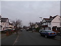
Electricity sub-station in Claremont Avenue
Image: © Basher Eyre
Taken: 21 Jan 2019
0.07 miles
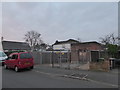
8
Bowater Gardens
New estate build on an old works site.
Image: © James Emmans
Taken: 6 Jun 2014
0.07 miles
9
Claremont Avenue
Semi-detached houses in Sunbury.
Image: © James Emmans
Taken: 1 May 2020
0.08 miles
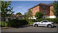
10

Batavia Road Flats
Residential road between The Avenue leading to the A308.
Image: © James Emmans
Taken: 28 Jun 2014
0.10 miles