IMAGES TAKEN NEAR TO
Saxonbury Avenue, SUNBURY-ON-THAMES, TW16 5HD
Introduction
This page details the photographs taken nearby to Saxonbury Avenue, TW16 5HD by members of the Geograph project.
The Geograph project started in 2005 with the aim of publishing, organising and preserving representative images for every square kilometre of Great Britain, Ireland and the Isle of Man.

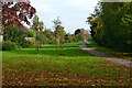
There are currently over 7.5m images from over14,400 individuals and you can help contribute to the project by visiting https://www.geograph.org.uk
Image Map
Images are licensed for reuse under creativecommons.org/licenses/by-sa/2.0
Notes
- Clicking on the map will re-center to the selected point.
- The higher the marker number, the further away the image location is from the centre of the postcode.
Image Listing (104 Images Found)
Images are licensed for reuse under creativecommons.org/licenses/by-sa/2.0
Image
Details
Distance
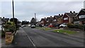
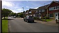
2
Old Orchard cul de sac
Sixties housing estate in Lower Sunbury. Some of the houses being substantially upgraded.
Image: © James Emmans
Taken: 6 Jun 2014
0.03 miles
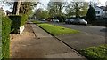
4
Street View
Saxonbury Avenue back street.
Image: © James Emmans
Taken: 6 Jun 2014
0.06 miles
5
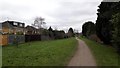
Footpath in Sunbury
Landscaped footpath that was going to become a road.
Image: © James Emmans
Taken: 21 Feb 2016
0.10 miles
6
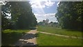
Sunbury Path
The abandoned road has been turned into a foot/cycle path and landscaped.
Image: © James Emmans
Taken: 7 Jun 2015
0.10 miles
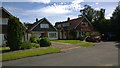
7
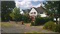
The Avenue
Detached houses with good sized gardens.
Image: © James Emmans
Taken: 27 Jun 2015
0.10 miles
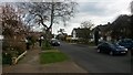
8
The Avenue
Residential street with detached houses.
Image: © James Emmans
Taken: 11 Apr 2015
0.10 miles
9
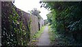
Historic Path - Rope Walk
Rope-making was a thriving industry in the 1700's.
Image: © James Emmans
Taken: 6 Jun 2014
0.11 miles