IMAGES TAKEN NEAR TO
The Avenue, SUNBURY-ON-THAMES, TW16 5EH
Introduction
This page details the photographs taken nearby to The Avenue, TW16 5EH by members of the Geograph project.
The Geograph project started in 2005 with the aim of publishing, organising and preserving representative images for every square kilometre of Great Britain, Ireland and the Isle of Man.

There are currently over 7.5m images from over14,400 individuals and you can help contribute to the project by visiting https://www.geograph.org.uk
Image Map
Images are licensed for reuse under creativecommons.org/licenses/by-sa/2.0
Notes
- Clicking on the map will re-center to the selected point.
- The higher the marker number, the further away the image location is from the centre of the postcode.
Image Listing (70 Images Found)
Images are licensed for reuse under creativecommons.org/licenses/by-sa/2.0
Image
Details
Distance
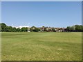
2
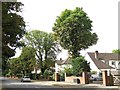
The Avenue - Sports Grounds
Sports ground used by Kempton Cricket Club.
http://www.pitchero.com/clubs/kemptoncricketclub
Image: © James Emmans
Taken: 3 Apr 2016
0.03 miles
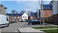
5
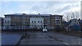
Sunbury Housing Development
Flats to the Northern part of the enclosed site.
Image: © James Emmans
Taken: 8 Feb 2016
0.08 miles
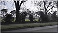
6
Cricket Ground view towards Kempton Park Race Course Stand
The race course floodlights dot the horizon.
Image: © James Emmans
Taken: 24 Apr 2020
0.09 miles
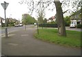
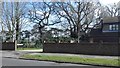
9
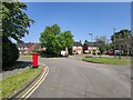
Roundabout on Pine Wood
Residential streets with detached houses.
Image: © James Emmans
Taken: 24 Apr 2020
0.09 miles
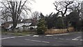
10
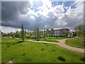
Landscaping for new Housing Estate
The sports grounds has been developed into a housing development.
Image: © James Emmans
Taken: 1 May 2020
0.10 miles