IMAGES TAKEN NEAR TO
Sunna Gardens, SUNBURY-ON-THAMES, TW16 5EE
Introduction
This page details the photographs taken nearby to Sunna Gardens, TW16 5EE by members of the Geograph project.
The Geograph project started in 2005 with the aim of publishing, organising and preserving representative images for every square kilometre of Great Britain, Ireland and the Isle of Man.

There are currently over 7.5m images from over14,400 individuals and you can help contribute to the project by visiting https://www.geograph.org.uk
Image Map
Images are licensed for reuse under creativecommons.org/licenses/by-sa/2.0
Notes
- Clicking on the map will re-center to the selected point.
- The higher the marker number, the further away the image location is from the centre of the postcode.
Image Listing (69 Images Found)
Images are licensed for reuse under creativecommons.org/licenses/by-sa/2.0
Image
Details
Distance
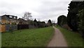
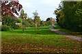
3
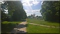
Sunbury Path
The abandoned road has been turned into a foot/cycle path and landscaped.
Image: © James Emmans
Taken: 7 Jun 2015
0.05 miles
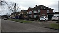
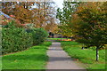
5
Footpath in Sunbury
Landscaped footpath that was going to become a road.
Image: © James Emmans
Taken: 21 Feb 2016
0.06 miles
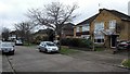
6
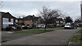
Sunna Gardens
Residential road with a van delivering food to a customer.
Image: © James Emmans
Taken: 21 Feb 2016
0.07 miles
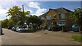
7
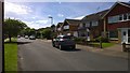
Street View
Saxonbury Avenue back street.
Image: © James Emmans
Taken: 6 Jun 2014
0.08 miles
8
Path between Sunna Gardens and French Street
Image: © David Martin
Taken: 27 Oct 2015
0.09 miles
10
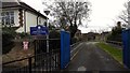
Entrance to Chennestone School
Primary school
http://www.chennestone.surrey.sch.uk/home.html
Image: © James Emmans
Taken: 21 Feb 2016
0.09 miles