IMAGES TAKEN NEAR TO
Kingston Road, ASHFORD, TW15 3SJ
Introduction
This page details the photographs taken nearby to Kingston Road, TW15 3SJ by members of the Geograph project.
The Geograph project started in 2005 with the aim of publishing, organising and preserving representative images for every square kilometre of Great Britain, Ireland and the Isle of Man.

There are currently over 7.5m images from over14,400 individuals and you can help contribute to the project by visiting https://www.geograph.org.uk
Image Map
Images are licensed for reuse under creativecommons.org/licenses/by-sa/2.0
Notes
- Clicking on the map will re-center to the selected point.
- The higher the marker number, the further away the image location is from the centre of the postcode.
Image Listing (36 Images Found)
Images are licensed for reuse under creativecommons.org/licenses/by-sa/2.0
Image
Details
Distance
1

Celia Crescent - Ashford
An estate of bungalows.
Image: © James Emmans
Taken: 7 May 2016
0.04 miles

3
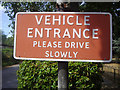
Old sign at entrance to Fordbridge Park
Image: © David Howard
Taken: 11 Jul 2010
0.08 miles
5
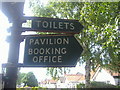
Old fingerposts at entrance to Fordbridge Park
Image: © David Howard
Taken: 11 Jul 2010
0.08 miles
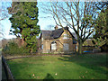
6
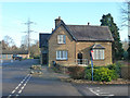
Beresford House in Fordbridge Park
It seems to have been the house for New Farm before this was a public park.
Image: © Robin Webster
Taken: 17 Jan 2015
0.09 miles
7
Beresford House in Fordbridge Park
It seems to have been the house for New Farm before this was a public park.
Image: © Robin Webster
Taken: 17 Jan 2015
0.09 miles
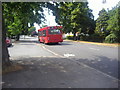
8
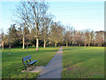
Park bench and path
In Fordbridge Park.
Image: © Robin Webster
Taken: 17 Jan 2015
0.10 miles
9
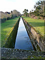
Staines Reservoirs Aqueduct
Viewed from the Ashford Road bridge.
Image: © Robin Webster
Taken: 17 Jan 2015
0.12 miles
10
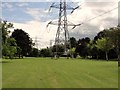
Pylon in Public Park
This shows a pylon line routed through a popular park and going along the side of the A308 towards The Crooked Billet Roundabout near Staines.
Image: © Anonymous
Taken: 18 Jul 2009
0.13 miles