IMAGES TAKEN NEAR TO
Stanwell Road, ASHFORD, TW15 3QN
Introduction
This page details the photographs taken nearby to Stanwell Road, TW15 3QN by members of the Geograph project.
The Geograph project started in 2005 with the aim of publishing, organising and preserving representative images for every square kilometre of Great Britain, Ireland and the Isle of Man.

There are currently over 7.5m images from over14,400 individuals and you can help contribute to the project by visiting https://www.geograph.org.uk
Image Map
Images are licensed for reuse under creativecommons.org/licenses/by-sa/2.0
Notes
- Clicking on the map will re-center to the selected point.
- The higher the marker number, the further away the image location is from the centre of the postcode.
Image Listing (7 Images Found)
Images are licensed for reuse under creativecommons.org/licenses/by-sa/2.0
Image
Details
Distance
1
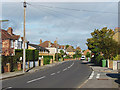
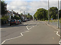
Stanwell Road, Ashford
Looking north along Stanwell Road, the main road through the 1930s housing estates to the west of the town centre.
Image: © Alan Hunt
Taken: 20 Oct 2014
0.12 miles
3
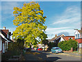
False acacia, Tennyson Road
A fine false acacia in Tennyson Road, Ashford.
Image: © Alan Hunt
Taken: 20 Oct 2014
0.16 miles
4
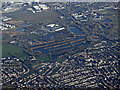
Bedfont Lakes Country park from the air
Part of Heathrow Airport can be seen in the top left corner.
Friend of Bedfont Lakes web site: https://www.bedfontlakes.co.uk/ .
Image: © Thomas Nugent
Taken: 19 Jan 2020
0.17 miles
5
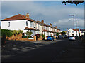
Fairholme Road, Ashford
The 1930s housing estates to the west of Ashford town centre.
Image: © Alan Hunt
Taken: 20 Oct 2014
0.19 miles
6
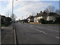
Woodthorpe Road
Woodthorpe Road passing West Close
Image: © Shaun Ferguson
Taken: 20 Feb 2013
0.19 miles
7
Woodthorpe Road
A view along Woodthorpe Road in Ashford. The entrance to Bronzefield prison is marked by the blue sign on the right.
Image: © Alan Hunt
Taken: 6 Aug 2012
0.23 miles