IMAGES TAKEN NEAR TO
Station Yard, Stanwell Road, ASHFORD, TW15 3DT
Introduction
This page details the photographs taken nearby to Station Yard, Stanwell Road, TW15 3DT by members of the Geograph project.
The Geograph project started in 2005 with the aim of publishing, organising and preserving representative images for every square kilometre of Great Britain, Ireland and the Isle of Man.

There are currently over 7.5m images from over14,400 individuals and you can help contribute to the project by visiting https://www.geograph.org.uk
Image Map
Images are licensed for reuse under creativecommons.org/licenses/by-sa/2.0
Notes
- Clicking on the map will re-center to the selected point.
- The higher the marker number, the further away the image location is from the centre of the postcode.
Image Listing (33 Images Found)
Images are licensed for reuse under creativecommons.org/licenses/by-sa/2.0
Image
Details
Distance
1
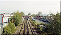
Ashford (Middlesex) station, 1992
View eastward from the Stanwell Road bridge, towards London: ex-LSWR Waterloo - Staines - Reading secondary main line. (Note that the station is still called 'Middlesex' although the County ceased to exist nearly 40 years ago and this now Surrey).
Image: © Ben Brooksbank
Taken: 23 Jun 1992
0.03 miles
2
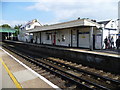
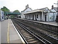
Ashford station
Ashford station was opened on 22nd August 1848 by the Windsor Staines & South Western Railway Company. This company was absorbed by the London & South Western Railway, and in turn it became part of the Southern Railway during the Grouping of 1923.
This view from the up platform looks across to the down platform and the main entrance. To the left is in the direction of London Waterloo. The next station in this direction is Feltham.
Image: © Marathon
Taken: 10 Sep 2014
0.06 miles
3
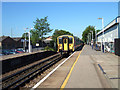
Windsor to London train arriving at Ashford station
Image: © Rachel Keegan
Taken: 3 Jun 2006
0.06 miles
4
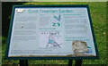
Visitor Board, Scott Freeman Garden
About the local councillor who gave this small park to the community.
Image: © Des Blenkinsopp
Taken: 15 Aug 2023
0.07 miles
5
Ashford (Middlesex) railway station, Surrey
Opened in 1848 by the Windsor, Staines and South Western Railway. View east towards Feltham, Richmond and London. The station name in timetables hasn't kept pace with county changes.
Image: © Nigel Thompson
Taken: 28 Apr 2011
0.07 miles
6
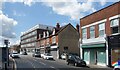
Woodthorpe Road, Ashford
An old shop terrace in between more recent developments.
Image: © Des Blenkinsopp
Taken: 15 Aug 2023
0.08 miles
7
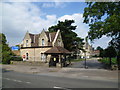
Entrance to St James School for Senior Boys
The juniors' and senior girls' schools of St James' Independent Schools are in the London Borough of Hammersmith and Fulham, while the senior boys' school is here in Ashford. This view looks across Church Road to the entrance lodge which is built in the same style as the school itself, seen behind.
Image: © Marathon
Taken: 10 Sep 2014
0.08 miles
8
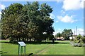
The Scott Freeman Garden
Part of a small park donated by Harry Scott Freeman (1876-1968), Olympic Gold Medallist, Lord of the Manor of Ashford, Town Clerk of Staines UDC and member of the England Ice Hockey team.
He sounds a remarkable person. More about him and Ashford on the visitor board.
Image
Image: © Des Blenkinsopp
Taken: 15 Aug 2023
0.08 miles
9

Landscaping on green alongside Stanwell Road
This small triangular green alongside Stanwell Road with Church Road ahead and not far from Ashford station, has been provided with a number of raised beds, landscaped as here to improve its appearance.
Image: © Marathon
Taken: 10 Sep 2014
0.08 miles
10
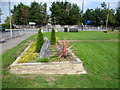
Green alongside Stanwell Road
This small triangular green alongside Stanwell Road with Church Road ahead and not far from Ashford station, has been provided with a number of raised beds, landscaped as here to improve its appearance.
Image: © Marathon
Taken: 10 Sep 2014
0.08 miles