IMAGES TAKEN NEAR TO
Salcombe Road, ASHFORD, TW15 3BS
Introduction
This page details the photographs taken nearby to Salcombe Road, TW15 3BS by members of the Geograph project.
The Geograph project started in 2005 with the aim of publishing, organising and preserving representative images for every square kilometre of Great Britain, Ireland and the Isle of Man.

There are currently over 7.5m images from over14,400 individuals and you can help contribute to the project by visiting https://www.geograph.org.uk
Image Map
Images are licensed for reuse under creativecommons.org/licenses/by-sa/2.0
Notes
- Clicking on the map will re-center to the selected point.
- The higher the marker number, the further away the image location is from the centre of the postcode.
Image Listing (16 Images Found)
Images are licensed for reuse under creativecommons.org/licenses/by-sa/2.0
Image
Details
Distance

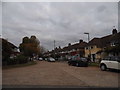
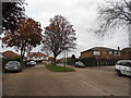
3
Stanwell Road at the junction with Gordon Road
Image: © David Howard
Taken: 2 Nov 2014
0.14 miles

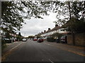
6
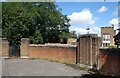
Old Deco Style Gateway
Long disused but with that unmistakeable 1930s style which can still be found in a lot of places in an area which was being developed in the years before WW2.
Behind are the buildings of Thomas Knyvett College.
Image: © Des Blenkinsopp
Taken: 15 Aug 2023
0.14 miles
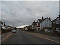
8
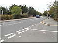
Stanwell Road at the junction of Station Crescent
Image: © David Howard
Taken: 26 Oct 2014
0.16 miles