IMAGES TAKEN NEAR TO
Desford Way, ASHFORD, TW15 3AR
Introduction
This page details the photographs taken nearby to Desford Way, TW15 3AR by members of the Geograph project.
The Geograph project started in 2005 with the aim of publishing, organising and preserving representative images for every square kilometre of Great Britain, Ireland and the Isle of Man.

There are currently over 7.5m images from over14,400 individuals and you can help contribute to the project by visiting https://www.geograph.org.uk
Image Map
Images are licensed for reuse under creativecommons.org/licenses/by-sa/2.0
Notes
- Clicking on the map will re-center to the selected point.
- The higher the marker number, the further away the image location is from the centre of the postcode.
Image Listing (12 Images Found)
Images are licensed for reuse under creativecommons.org/licenses/by-sa/2.0
Image
Details
Distance
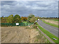
2
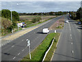
A puzzling right turn off eastbound A30
Clearly indicated no U-turn, but the Google Maps lady told me to make a U-turn here, having come out of Short Lane with no right turn and needing to go west. I ignored this and used a roundabout further on. Looking at the road layout, a valid right turn would seem to be to gain access to the road just seen slipping off on the right, which, after giving access to two further roads, rejoins the closely parallel main A30. Is this the legal way to do it?
Image: © Robin Webster
Taken: 22 Oct 2017
0.09 miles

5
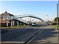
View north from A30 footbridge
Looking along Short Lane. Behind the palisade fencing is Ashford Sports Club, accessed further up the lane.
Image: © Robin Webster
Taken: 22 Oct 2017
0.14 miles
6
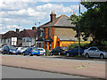
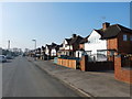
Houses along the A30, London Road
An eye-catching house which seems to be in use as a car wash.
Image: © Alan Hunt
Taken: 5 Jun 2014
0.17 miles
7
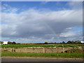
Rainbow seen from Short Lane
The left end was visible for a time Image, and now the right end, but the full rainbow never appeared.
Image: © Robin Webster
Taken: 22 Oct 2017
0.20 miles
8
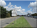
Welcome to Bedfont
In the middle of the Roman Road which is now the A30.
Surrey behind me and the London Borough of Hounslow in front.
Bedfont is twinned with places in India, Pakistan, Palestine and France.
Image: © Des Blenkinsopp
Taken: 15 Aug 2023
0.25 miles
9
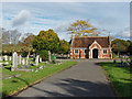
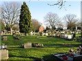
Ashford cemetery
The cemetery to the north of the A30. This cemetery dates back to the Edwardian era.
Image: © Alan Hunt
Taken: 20 Oct 2014
0.25 miles