IMAGES TAKEN NEAR TO
Manor Road, ASHFORD, TW15 2SF
Introduction
This page details the photographs taken nearby to Manor Road, TW15 2SF by members of the Geograph project.
The Geograph project started in 2005 with the aim of publishing, organising and preserving representative images for every square kilometre of Great Britain, Ireland and the Isle of Man.

There are currently over 7.5m images from over14,400 individuals and you can help contribute to the project by visiting https://www.geograph.org.uk
Image Map
Images are licensed for reuse under creativecommons.org/licenses/by-sa/2.0
Notes
- Clicking on the map will re-center to the selected point.
- The higher the marker number, the further away the image location is from the centre of the postcode.
Image Listing (11 Images Found)
Images are licensed for reuse under creativecommons.org/licenses/by-sa/2.0
Image
Details
Distance
1

Ashford Manor Golf Club - Ashford Middlesex (Surrey)
Image: © James Emmans
Taken: 7 May 2016
0.05 miles

4
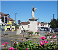
Ashford War Memorial
At the junction of Fordbridge and Church Roads.
Image: © Des Blenkinsopp
Taken: 5 Jul 2017
0.21 miles
5
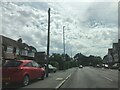
Church Road at the junction of Fordbridge Road
Image: © David Howard
Taken: 2 Nov 2014
0.21 miles
6
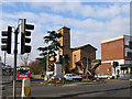
The War Memorial, Ashford, Middlesex
The photo also shows St Michael's Roman Catholic church (designed by Sir Giles Gilbert Scott)
Image: © Rachel Keegan
Taken: 26 Mar 2004
0.22 miles
7

Ashford Manor Golf Club
North east boundary looking west.
Image: © James Emmans
Taken: 7 May 2016
0.23 miles
8
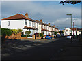
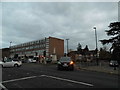
Fairholme Road, Ashford
The 1930s housing estates to the west of Ashford town centre.
Image: © Alan Hunt
Taken: 20 Oct 2014
0.24 miles
9

Ashford Manor Golf Club - Ashford Middlesex (Surrey)
Club House close to Fordbridge Road on Western edge of Course.
Image: © James Emmans
Taken: 7 May 2016
0.24 miles
10
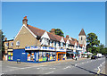
Shops, Church Road, Ashford
St Michael's Church at the end of the terrace.
Image: © Des Blenkinsopp
Taken: 5 Jul 2017
0.24 miles