IMAGES TAKEN NEAR TO
Town Tree Road, ASHFORD, TW15 2PW
Introduction
This page details the photographs taken nearby to Town Tree Road, TW15 2PW by members of the Geograph project.
The Geograph project started in 2005 with the aim of publishing, organising and preserving representative images for every square kilometre of Great Britain, Ireland and the Isle of Man.

There are currently over 7.5m images from over14,400 individuals and you can help contribute to the project by visiting https://www.geograph.org.uk
Image Map
Images are licensed for reuse under creativecommons.org/licenses/by-sa/2.0
Notes
- Clicking on the map will re-center to the selected point.
- The higher the marker number, the further away the image location is from the centre of the postcode.
Image Listing (60 Images Found)
Images are licensed for reuse under creativecommons.org/licenses/by-sa/2.0
Image
Details
Distance
1
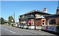
The Kings Head
A pub in the Marston's Brewery estate. One of a group of buildings on an island encircled by main roads.
Image: © Des Blenkinsopp
Taken: 5 Jul 2017
0.04 miles
2
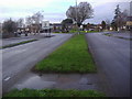
Junction of Convent Road and Feltham Road Ashford
Image: © David Howard
Taken: 27 Feb 2011
0.07 miles
5
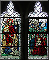
St Matthew, Ashford - Stained glass window
Image: © John Salmon
Taken: 18 Nov 2016
0.08 miles
6
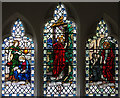
St Matthew, Ashford - Stained glass window
Image: © John Salmon
Taken: 18 Nov 2016
0.08 miles
7
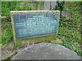
Site of the ancient church of St Michael, Ashford
The present church of St Matthew was built between 1858 and 1865. Further to the east in the churchyard is this tablet marking the site of the previous church, dedicated to St Michael, which was demolished at that time. See also http://www.geograph.org.uk/photo/4162177
Image: © Marathon
Taken: 10 Sep 2014
0.08 miles
8

Site of the ancient church of St Michael, Ashford
The earliest known reference to a Christian church on this site is a record of Edward I in 1293 granting a dispensation of taxes at the time of the Crusades. The Medieval structure dedicated to St Michael was rebuilt in 1797. The present parish church was designed by William Butterfield and built between 1858 and 1865. The church of 1797 was demolished and the tablet in the churchyard ahead marks the site of the chancel of this church - see http://www.geograph.org.uk/photo/4162189
Image: © Marathon
Taken: 10 Sep 2014
0.08 miles
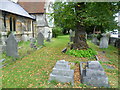
9
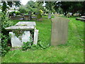
In St Matthew's Churchyard, Ashford
The earliest known reference to a Christian church on this site is a record of Edward I in 1293 granting a dispensation of taxes at the time of the Crusades. The Medieval structure dedicated to St Michael was rebuilt in 1797. The present parish church was designed by William Butterfield and built between 1858 and 1865. The church of 1797 was demolished and a tablet in the churchyard ahead marks the site of the chancel of this church - see http://www.geograph.org.uk/photo/4162189
Image: © Marathon
Taken: 10 Sep 2014
0.09 miles
10
In St Matthew's Churchyard, Ashford
The earliest known reference to a Christian church on this site is a record of Edward I in 1293 granting a dispensation of taxes at the time of the Crusades. The Medieval structure dedicated to St Michael was rebuilt in 1797. The present parish church, the south aisle of which is on the left here, was designed by William Butterfield and built between 1858 and 1865. The church of 1797 was demolished and a tablet in the churchyard marks the site of the chancel of this church - see http://www.geograph.org.uk/photo/4162189
Image: © Marathon
Taken: 10 Sep 2014
0.10 miles