IMAGES TAKEN NEAR TO
Fontmell Close, ASHFORD, TW15 2NN
Introduction
This page details the photographs taken nearby to Fontmell Close, TW15 2NN by members of the Geograph project.
The Geograph project started in 2005 with the aim of publishing, organising and preserving representative images for every square kilometre of Great Britain, Ireland and the Isle of Man.

There are currently over 7.5m images from over14,400 individuals and you can help contribute to the project by visiting https://www.geograph.org.uk
Image Map
Images are licensed for reuse under creativecommons.org/licenses/by-sa/2.0
Notes
- Clicking on the map will re-center to the selected point.
- The higher the marker number, the further away the image location is from the centre of the postcode.
Image Listing (50 Images Found)
Images are licensed for reuse under creativecommons.org/licenses/by-sa/2.0
Image
Details
Distance
1

Ashford Manor Golf Club
North east boundary looking west.
Image: © James Emmans
Taken: 7 May 2016
0.10 miles
2

Gilmore Crescent viewed from Ashford Manor Golf Club
Image: © James Emmans
Taken: 7 May 2016
0.11 miles

4
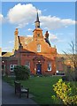
The Rowland Hill Almshouses, Feltham Hill Road
The Rev. Rowland Hill established almshouses in central London early in the 19th century. The present buildings in Ashford would seem to date from about 1900.
Image: © Stefan Czapski
Taken: 1 Mar 2014
0.17 miles
5

Ashford Manor Golf Club - Ashford Middlesex (Surrey)
Image: © James Emmans
Taken: 7 May 2016
0.18 miles
6
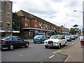
Church Road, Ashford, Middlesex
This photograph shows the arrival of the bride for a wedding at St Matthew's Church
Image: © Rachel Keegan
Taken: 28 Aug 2004
0.19 miles
8
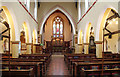
In St Matthew's Churchyard, Ashford
The earliest known reference to a Christian church on this site is a record of Edward I in 1293 granting a dispensation of taxes at the time of the Crusades. The Medieval structure dedicated to St Michael was rebuilt in 1797. The present parish church, the south aisle of which is on the left here, was designed by William Butterfield and built between 1858 and 1865. The church of 1797 was demolished and a tablet in the churchyard marks the site of the chancel of this church - see http://www.geograph.org.uk/photo/4162189
Image: © Marathon
Taken: 10 Sep 2014
0.19 miles
9
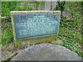
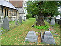
Site of the ancient church of St Michael, Ashford
The present church of St Matthew was built between 1858 and 1865. Further to the east in the churchyard is this tablet marking the site of the previous church, dedicated to St Michael, which was demolished at that time. See also http://www.geograph.org.uk/photo/4162177
Image: © Marathon
Taken: 10 Sep 2014
0.20 miles
10

Site of the ancient church of St Michael, Ashford
The earliest known reference to a Christian church on this site is a record of Edward I in 1293 granting a dispensation of taxes at the time of the Crusades. The Medieval structure dedicated to St Michael was rebuilt in 1797. The present parish church was designed by William Butterfield and built between 1858 and 1865. The church of 1797 was demolished and the tablet in the churchyard ahead marks the site of the chancel of this church - see http://www.geograph.org.uk/photo/4162189
Image: © Marathon
Taken: 10 Sep 2014
0.20 miles