1
Ashford (Middlesex) station, 1992
View eastward from the Stanwell Road bridge, towards London: ex-LSWR Waterloo - Staines - Reading secondary main line. (Note that the station is still called 'Middlesex' although the County ceased to exist nearly 40 years ago and this now Surrey).
Image: © Ben Brooksbank
Taken: 23 Jun 1992
0.06 miles
2
Woodthorpe Road, Ashford
An old shop terrace in between more recent developments.
Image: © Des Blenkinsopp
Taken: 15 Aug 2023
0.06 miles
3
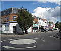
Lloyds Bank on the Corner
Woodthorpe Road, Ashford.
Image: © Des Blenkinsopp
Taken: 10 May 2017
0.09 miles
4
Windsor to London train arriving at Ashford station
Image: © Rachel Keegan
Taken: 3 Jun 2006
0.09 miles
5
Ashford station
Ashford station was opened on 22nd August 1848 by the Windsor Staines & South Western Railway Company. This company was absorbed by the London & South Western Railway, and in turn it became part of the Southern Railway during the Grouping of 1923.
This view from the up platform looks across to the down platform and the main entrance. To the left is in the direction of London Waterloo. The next station in this direction is Feltham.
Image: © Marathon
Taken: 10 Sep 2014
0.09 miles
6
Ashford (Middlesex) railway station, Surrey
Opened in 1848 by the Windsor, Staines and South Western Railway. View east towards Feltham, Richmond and London. The station name in timetables hasn't kept pace with county changes.
Image: © Nigel Thompson
Taken: 28 Apr 2011
0.09 miles
7
Changes on the Corner, Ashford
Townscapes are never the same for long.
Since I was last standing in this same spot
Image the building on the corner has gained an upper storey.
And, of course, it's not Lloyds Bank any more.
Why do we still have bank holidays when there aren't any?
Image: © Des Blenkinsopp
Taken: 15 Aug 2023
0.09 miles
8
Visitor Board, Scott Freeman Garden
About the local councillor who gave this small park to the community.
Image: © Des Blenkinsopp
Taken: 15 Aug 2023
0.11 miles
9
Lodge, Masons
Stonemasons, Clarendon Road, Ashford.
Image: © Des Blenkinsopp
Taken: 10 May 2017
0.12 miles
10
Approaching the railway bridge, Church Road, Ashford
The bridge over the railway at the north end of the town is something of a local landmark.
Image: © Stefan Czapski
Taken: 9 Jan 2014
0.12 miles


