IMAGES TAKEN NEAR TO
Fairways, ASHFORD, TW15 2AA
Introduction
This page details the photographs taken nearby to Fairways, TW15 2AA by members of the Geograph project.
The Geograph project started in 2005 with the aim of publishing, organising and preserving representative images for every square kilometre of Great Britain, Ireland and the Isle of Man.

There are currently over 7.5m images from over14,400 individuals and you can help contribute to the project by visiting https://www.geograph.org.uk
Image Map
Images are licensed for reuse under creativecommons.org/licenses/by-sa/2.0
Notes
- Clicking on the map will re-center to the selected point.
- The higher the marker number, the further away the image location is from the centre of the postcode.
Image Listing (12 Images Found)
Images are licensed for reuse under creativecommons.org/licenses/by-sa/2.0
Image
Details
Distance
1
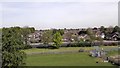
View from top of Queen Mary Reservoir Embankment
Image: © James Emmans
Taken: 6 May 2016
0.07 miles
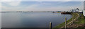
2
Queen Mary Reservoir from the north
This is London's largest reservoir (it's west of Sunbury on Thames) and is the home of the Queen Mary Sailing club. The picture was taken from the A308.
Image: © steve
Taken: 5 Aug 2005
0.13 miles
3
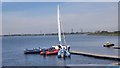
Queen Mary Reservoir - Sailing Club Boats
One of London's larger Reservoir with 200 million gallons pumped from the Thames Daily.
Image: © James Emmans
Taken: 6 May 2016
0.14 miles
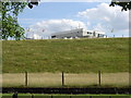
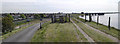
4
Queen Mary Reservoir
Spill way is close to the horizon.
Image: © James Emmans
Taken: 6 May 2016
0.16 miles
5
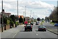
A308, Staines Road West
The A308 runs between Kensington, in London, and Bisham in Berkshire, staying no more than 3 miles from the River Thames http://en.wikipedia.org/wiki/A308_road . The section running on the south side of the town of Ashford is named Staines Road West.
Image: © David Dixon
Taken: 11 Apr 2015
0.21 miles
6
Queen Mary Reservoir Embankment - Bird Watchers Gate
Bird Watchers need a licence to walk around the embankment.
Image: © James Emmans
Taken: 6 May 2016
0.21 miles
7
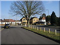
Denman Drive
Denman Drive at junction with School Road
Image: © Shaun Ferguson
Taken: 20 Feb 2013
0.21 miles
8
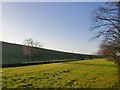
Reservoir bank, Queen Mary Reservoir
Looking west along the northern bank of this major reservoir. The deeply shaded strip running right across the picture is in fact a trench carrying the Staines Reservoirs aqueduct.
Photo taken through a fence, by the A308 Kingston-Staines road.
Image: © Stefan Czapski
Taken: 29 Dec 2013
0.21 miles
9
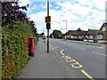
Postbox TW15 162D, School Road, Ashford
A George V box, with attached drop box.
Image: © Robin Webster
Taken: 12 Aug 2017
0.22 miles
10
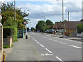
School Road, Ashford
The bus stop is The Coppice, for service 290 towards Sunbury.
Image: © Robin Webster
Taken: 12 Aug 2017
0.23 miles