IMAGES TAKEN NEAR TO
Cornerside, ASHFORD, TW15 1UY
Introduction
This page details the photographs taken nearby to Cornerside, TW15 1UY by members of the Geograph project.
The Geograph project started in 2005 with the aim of publishing, organising and preserving representative images for every square kilometre of Great Britain, Ireland and the Isle of Man.

There are currently over 7.5m images from over14,400 individuals and you can help contribute to the project by visiting https://www.geograph.org.uk
Image Map
Images are licensed for reuse under creativecommons.org/licenses/by-sa/2.0
Notes
- Clicking on the map will re-center to the selected point.
- The higher the marker number, the further away the image location is from the centre of the postcode.
Image Listing (33 Images Found)
Images are licensed for reuse under creativecommons.org/licenses/by-sa/2.0
Image
Details
Distance
1
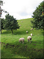
Ashford Road from the corner of Littleton Road
The grass is the edge of the Queen Mary Reservoir, and the verges are normally occupied by sheep.
Image: © David Howard
Taken: 9 Jun 2013
0.04 miles
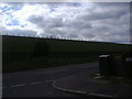
2
Charlton Road from the corner of Littleton Road
The verges are round the edge of Queen Mary Reservoir, and normally occupied by sheep
Image: © David Howard
Taken: 9 Jun 2013
0.04 miles
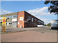
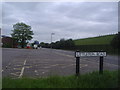
4
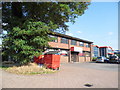
Thames House on Littleton industrial estate
Image: © David Howard
Taken: 26 Aug 2013
0.08 miles
7
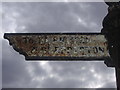
Old fingerpost on Littleton Road, Ashford
These were the earliest road signs made in Britain but were not subject to any specific design regulations until the 1930s.
Image: © David Howard
Taken: 9 Jun 2013
0.13 miles
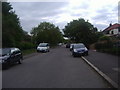
8
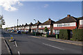
Spelthorne Lane
A uniform line of semi-detached houses in Spelthorne Lane.
Image: © Ian Capper
Taken: 10 Nov 2010
0.13 miles
9
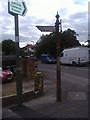
Ancient fingerpost on the corner of Littleton Road
Before the early 30s road signs were locally made, and this is one of the first signposts for road traffic although the road itself doesn't appear to be as old as that from the buildings.
Image: © David Howard
Taken: 9 Jun 2013
0.13 miles