IMAGES TAKEN NEAR TO
Staines Road West, ASHFORD, TW15 1RU
Introduction
This page details the photographs taken nearby to Staines Road West, TW15 1RU by members of the Geograph project.
The Geograph project started in 2005 with the aim of publishing, organising and preserving representative images for every square kilometre of Great Britain, Ireland and the Isle of Man.

There are currently over 7.5m images from over14,400 individuals and you can help contribute to the project by visiting https://www.geograph.org.uk
Image Map
Images are licensed for reuse under creativecommons.org/licenses/by-sa/2.0
Notes
- Clicking on the map will re-center to the selected point.
- The higher the marker number, the further away the image location is from the centre of the postcode.
Image Listing (19 Images Found)
Images are licensed for reuse under creativecommons.org/licenses/by-sa/2.0
Image
Details
Distance
1
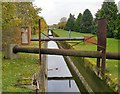
Aqueduct AQUEQ1ZZ
View ESE from the bridge at the junction of Littleton Road and Spelthorne Lane. The designation AQUEQ1ZZ appears on a Thames Water notice nearby.
Image: © Stefan Czapski
Taken: 25 Nov 2013
0.13 miles
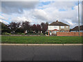
2
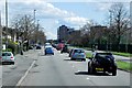
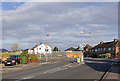
Staines Road West, Ashford
The A308 runs between Kensington, in London, and Bisham in Berkshire, staying no more than 3 miles from the River Thames http://en.wikipedia.org/wiki/A308_road . The section running on the south side of the town of Ashford is named Staines Road West.
Image: © David Dixon
Taken: 11 Apr 2015
0.14 miles
3
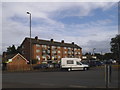
Flats on the corner of Littleton Road, Ashford
Image: © David Howard
Taken: 28 Jun 2015
0.16 miles
4
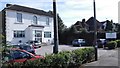
Sherwoods Vets - Ashford Common
Veterinary surgeons on the Staines Road West.
Image: © James Emmans
Taken: 5 Aug 2016
0.16 miles
6
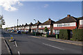
Spelthorne Lane
A uniform line of semi-detached houses in Spelthorne Lane.
Image: © Ian Capper
Taken: 10 Nov 2010
0.20 miles
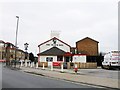
8
Spelthorne Lane, Ashford
Spelthorne is the Saxon phrase for "speech thorn tree" where the Elders of the Spelthorne Hundred met to discuss local law. The tree was of great importance. Spelthorne is one of the boroughs within the ancient county of Middlesex. This area is now under Surrey administration. There once stood the Spelthorne Inn just to the left of this photo, so the Lane could have got its name from the pub. Spelthorne Manor House was further along the Staines Road West in Sunbury, where the Spelthorne Grove Estate now stands.
Image: © David Howard
Taken: 9 Jun 2013
0.20 miles
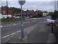
9
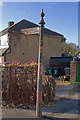
Signpost
Signpost to Charlton and Shepperton along Spelthorne Lane, at its junction with Littleton Lane (see Image).
Image: © Ian Capper
Taken: 10 Nov 2010
0.21 miles
10
Junction of Spelthorne Lane/Littleton Road/Bridge Gardens
Spelthorne Lane (towards the camera), Littleton Road (off to the left) and Bridge Gardens (away from the camera) meet here. The bridge is over the Staines Reservoirs Aqueduct. Against the white house just left of centre can be seen the old signpost in Image
Image: © Ian Capper
Taken: 10 Nov 2010
0.21 miles