IMAGES TAKEN NEAR TO
Garden Close, ASHFORD, TW15 1LH
Introduction
This page details the photographs taken nearby to Garden Close, TW15 1LH by members of the Geograph project.
The Geograph project started in 2005 with the aim of publishing, organising and preserving representative images for every square kilometre of Great Britain, Ireland and the Isle of Man.

There are currently over 7.5m images from over14,400 individuals and you can help contribute to the project by visiting https://www.geograph.org.uk
Image Map
Images are licensed for reuse under creativecommons.org/licenses/by-sa/2.0
Notes
- Clicking on the map will re-center to the selected point.
- The higher the marker number, the further away the image location is from the centre of the postcode.
Image Listing (8 Images Found)
Images are licensed for reuse under creativecommons.org/licenses/by-sa/2.0
Image
Details
Distance
3
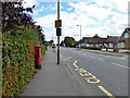
Postbox TW15 162D, School Road, Ashford
A George V box, with attached drop box.
Image: © Robin Webster
Taken: 12 Aug 2017
0.23 miles
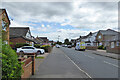
4
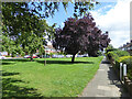
Houses on Elgin Avenue
There is a wedge of green here, at the junction with Cecil Road.
Image: © Robin Webster
Taken: 12 Aug 2017
0.23 miles
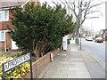
6
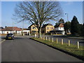
Denman Drive
Denman Drive at junction with School Road
Image: © Shaun Ferguson
Taken: 20 Feb 2013
0.24 miles
7
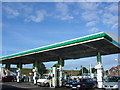
Solar powered Petrol Station
This petrol station by the A308 in Spelthorne has semi transparent solar panels on the canopy roof. In the background is the embankment for the Queen Mary reservoir
Image: © steve
Taken: 9 Aug 2005
0.24 miles
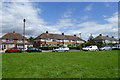
8
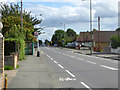
School Road, Ashford
The bus stop is The Coppice, for service 290 towards Sunbury.
Image: © Robin Webster
Taken: 12 Aug 2017
0.24 miles