IMAGES TAKEN NEAR TO
Dingle Road, ASHFORD, TW15 1HF
Introduction
This page details the photographs taken nearby to Dingle Road, TW15 1HF by members of the Geograph project.
The Geograph project started in 2005 with the aim of publishing, organising and preserving representative images for every square kilometre of Great Britain, Ireland and the Isle of Man.

There are currently over 7.5m images from over14,400 individuals and you can help contribute to the project by visiting https://www.geograph.org.uk
Image Map
Images are licensed for reuse under creativecommons.org/licenses/by-sa/2.0
Notes
- Clicking on the map will re-center to the selected point.
- The higher the marker number, the further away the image location is from the centre of the postcode.
Image Listing (8 Images Found)
Images are licensed for reuse under creativecommons.org/licenses/by-sa/2.0
Image
Details
Distance
1
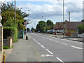
School Road, Ashford
The bus stop is The Coppice, for service 290 towards Sunbury.
Image: © Robin Webster
Taken: 12 Aug 2017
0.16 miles
2

The Rowland Hill Almshouses, Feltham Hill Road
The Rev. Rowland Hill established almshouses in central London early in the 19th century. The present buildings in Ashford would seem to date from about 1900.
Image: © Stefan Czapski
Taken: 1 Mar 2014
0.17 miles
3
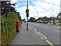
Postbox TW15 162D, School Road, Ashford
A George V box, with attached drop box.
Image: © Robin Webster
Taken: 12 Aug 2017
0.18 miles
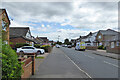
4
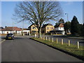
Denman Drive
Denman Drive at junction with School Road
Image: © Shaun Ferguson
Taken: 20 Feb 2013
0.18 miles
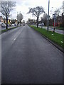
5
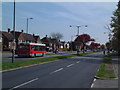
Convent Road, Ashford
This dual carriageway is quite a lot wider than the volume of traffic demands.
Image: © David Squire
Taken: 22 Apr 2006
0.19 miles
8
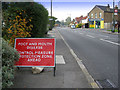
Feltham Road, Ashford, Middlesex
This photograph was taken at the time of the outbreak of foot and mouth disease in Surrey in 2007. It was quite a shock to see this sign in a residential area.
Image: © Rachel Keegan
Taken: 7 Oct 2007
0.25 miles