IMAGES TAKEN NEAR TO
Ascot Road, FELTHAM, TW14 8QH
Introduction
This page details the photographs taken nearby to Ascot Road, TW14 8QH by members of the Geograph project.
The Geograph project started in 2005 with the aim of publishing, organising and preserving representative images for every square kilometre of Great Britain, Ireland and the Isle of Man.

There are currently over 7.5m images from over14,400 individuals and you can help contribute to the project by visiting https://www.geograph.org.uk
Image Map
Images are licensed for reuse under creativecommons.org/licenses/by-sa/2.0
Notes
- Clicking on the map will re-center to the selected point.
- The higher the marker number, the further away the image location is from the centre of the postcode.
Image Listing (11 Images Found)
Images are licensed for reuse under creativecommons.org/licenses/by-sa/2.0
Image
Details
Distance
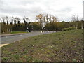
1

Expeditors on Ascot Road
Many airport related businesses are in the area, and if you are patient you can watch the planes coming in to land almost on the horizon.
Image: © David Howard
Taken: 26 Oct 2014
0.01 miles
2
Ascot Road looking towards Clockhouse Lane
Image: © David Howard
Taken: 26 Oct 2014
0.11 miles
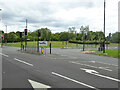
3
Ascot Road, Bedfont
Leading to the industrial estate on the left
Image: © David Howard
Taken: 26 Oct 2014
0.11 miles
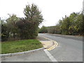
4
Turning for Expeditors off Clockhouse Lane
Expeditors is an American 'global logistics company'.
Image: © Robin Webster
Taken: 12 Aug 2017
0.13 miles
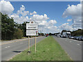
5
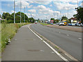
A30, The London Road
Looking east along the A30 as it leaves Ashford and enters East Bedfont
Image: © Alan Hunt
Taken: 5 Jun 2014
0.18 miles
6
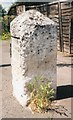
Old Milestone by the A30, Staines Road, Bedfont
Old Hounslow limestone square by the A30, in parish of East Bedfont (Hounslow District), Staines Road; Bedfont, by No. 778, 50m East of Ashford boundary, beside Orchard Café on path beside dual carriageway.
Inscription once read:-
HYDE PARK
CORNER
14 Miles
Surveyed
Milestone Society National ID: MX_le14
Image: © Milestone Society
Taken: Unknown
0.19 miles
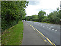
7
Welcome to Bedfont
In the middle of the Roman Road which is now the A30.
Surrey behind me and the London Borough of Hounslow in front.
Bedfont is twinned with places in India, Pakistan, Palestine and France.
Image: © Des Blenkinsopp
Taken: 15 Aug 2023
0.21 miles
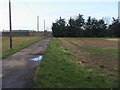
9
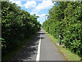
West Bedfont cycle path
The cycle path that runs from the A30 to Stanwell Road through the Heathrow biodiversity area.
Image: © Alan Hunt
Taken: 5 Jun 2014
0.22 miles
10
Drive down to Mayfield Farm
Off A30 London Road the drive down to Mayfield Farm
Image: © Shaun Ferguson
Taken: 15 Feb 2013
0.24 miles