IMAGES TAKEN NEAR TO
Thames Close, HAMPTON, TW12 2ET
Introduction
This page details the photographs taken nearby to Thames Close, TW12 2ET by members of the Geograph project.
The Geograph project started in 2005 with the aim of publishing, organising and preserving representative images for every square kilometre of Great Britain, Ireland and the Isle of Man.

There are currently over 7.5m images from over14,400 individuals and you can help contribute to the project by visiting https://www.geograph.org.uk
Image Map
Images are licensed for reuse under creativecommons.org/licenses/by-sa/2.0
Notes
- Clicking on the map will re-center to the selected point.
- The higher the marker number, the further away the image location is from the centre of the postcode.
Image Listing (213 Images Found)
Images are licensed for reuse under creativecommons.org/licenses/by-sa/2.0
Image
Details
Distance
1
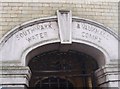
Clock tower inscription
This inscription appears on the clock tower depicted in Image
Image: © Ceri Thomas
Taken: 27 Jan 2010
0.01 miles
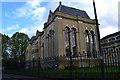
2
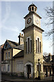
Water Works Clock Tower
This clock tower is by the easternmost entrance to Thames Water's treatment works which occupies most of the riverside land between Hampton and Sunbury. The inscription over the door reads Southwark and Vauxhall Water Company, one of the Victorian enterprises pre-dating the Metropolitan Water Board. http://en.wikipedia.org/wiki/Southwark_and_Vauxhall_Waterworks_Company
Image: © Des Blenkinsopp
Taken: 27 Mar 2009
0.01 miles
3
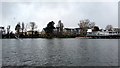
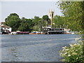
The Thames at Hampton, from Hurst Park
Image: © Mike Pennington
Taken: 27 Feb 2018
0.02 miles
4
Thames Riverside at Hampton, Surrey
In the background are buildings associated with the waterworks
Image: © Dr Neil Clifton
Taken: 28 Mar 1982
0.02 miles
5
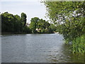
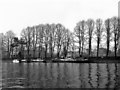
The River Thames downstream of Platt's Eyot
Image: © Mike Quinn
Taken: 6 Jun 2018
0.03 miles
6
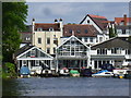
Hampton - Riverside
Boathouses on the north bank of the River Thames.
Image: © Colin Smith
Taken: 11 May 2015
0.04 miles
8
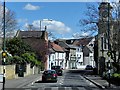
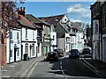
Hampton Village
The A308 runs between Kensington, in London, and Bisham in Berkshire, staying no more than 3 miles from the River Thames http://en.wikipedia.org/wiki/A308_road . It is very narrow and winding as it passes through Hampton village as Upper Subury Road and, briefly, Thames Street. This section often suffers from traffic congestion.
The ornate building with the tower is part of the Southwark & Vauxhall Water Company's Works.
Image: © David Dixon
Taken: 11 Apr 2015
0.05 miles
9
The River Thames upstream of Garrick's Eyot
Looking towards Image (photographed by Colin Smith).
Image: © Mike Quinn
Taken: 6 Jun 2018
0.06 miles
10
Upper Sunbury Road, Hampton
The A308 runs between Kensington, in London, and Bisham in Berkshire, staying no more than 3 miles from the River Thames http://en.wikipedia.org/wiki/A308_road . It is very narrow and winding as it passes through Hampton village as Upper Subury Road and, briefly, Thames Street. This section often suffers from traffic congestion.
The ornate building with the tower is part of the Southwark & Vauxhall Water Company's Works.
Image: © David Dixon
Taken: 11 Apr 2015
0.06 miles