IMAGES TAKEN NEAR TO
Chop Gate, MIDDLESBROUGH, TS9 7JD
Introduction
This page details the photographs taken nearby to TS9 7JD by members of the Geograph project.
The Geograph project started in 2005 with the aim of publishing, organising and preserving representative images for every square kilometre of Great Britain, Ireland and the Isle of Man.

There are currently over 7.5m images from over14,400 individuals and you can help contribute to the project by visiting https://www.geograph.org.uk
Image Map
Images are licensed for reuse under creativecommons.org/licenses/by-sa/2.0
Notes
- Clicking on the map will re-center to the selected point.
- The higher the marker number, the further away the image location is from the centre of the postcode.
Image Listing (13 Images Found)
Images are licensed for reuse under creativecommons.org/licenses/by-sa/2.0
Image
Details
Distance
1
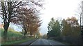
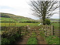
Newly Layered Hedge
Alongside the B1257.
Image: © Mick Garratt
Taken: 1 Apr 2010
0.09 miles
5
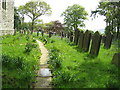
Footpath outside St Hilda's Church
Image: © William Metcalfe
Taken: 16 May 2009
0.19 miles
7
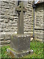
War Memorial
Outside St Hilda's Church
Image: © William Metcalfe
Taken: 16 May 2009
0.19 miles
8
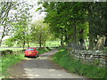
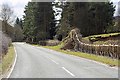
Road outside St Hilda's Church
Very quiet country road leading to and from the church.
Image: © William Metcalfe
Taken: 16 May 2009
0.19 miles
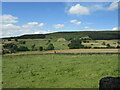
9
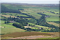
The village of Seave Green from Cold Moor
Image: © Bill Boaden
Taken: 14 Jul 2009
0.20 miles
10
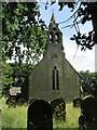
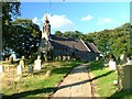
St Hilda's church
St Hilda's church, Seave Green.
Image: © T Eyre
Taken: 7 Jul 2023
0.21 miles