
IMAGES TAKEN NEAR TO
Ingleby Road, MIDDLESBROUGH, TS9 7FA
Introduction
This page details the photographs taken nearby to Ingleby Road, TS9 7FA by members of the Geograph project.
The Geograph project started in 2005 with the aim of publishing, organising and preserving representative images for every square kilometre of Great Britain, Ireland and the Isle of Man.

There are currently over 7.5m images from over14,400 individuals and you can help contribute to the project by visiting https://www.geograph.org.uk
Image Map
Images are licensed for reuse under creativecommons.org/licenses/by-sa/2.0
Notes
- Clicking on the map will re-center to the selected point.
- The higher the marker number, the further away the image location is from the centre of the postcode.
Image Listing (3 Images Found)
Images are licensed for reuse under creativecommons.org/licenses/by-sa/2.0
Image
Details
Distance
1
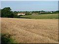
Pond House
Pond House probably dates from about 1780 although it has been much renovated and extended. The pond from which it gets its name has long since been filled in.
Reference:
Parva Broctune
By June Hodgson (2005)
Image: © Mick Garratt
Taken: 24 Sep 2005
0.05 miles
2
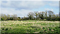
Rough grazing on north side of Ingleby Greenhow Road
The road is on the far side of the hedge bounding the small field. So rough is the field that it might not be in use at all, even for grazing.
Image: © Trevor Littlewood
Taken: 25 Apr 2022
0.23 miles
3
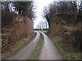
Dismantled railway bridge near Whitehouse Farm
This photograph shows a view of the remains of the old railway bridge near Whitehouse Farm. Before it was dismantled, the railway linked Battersby Junction with Stokesley and stations further west. The picture was taken from the south approach to the bridge looking in a Northerly direction towards Castle House Farm.
Image: © Philip Barker
Taken: 7 Feb 2010
0.24 miles