IMAGES TAKEN NEAR TO
Great Broughton, MIDDLESBROUGH, TS9 7EU
Introduction
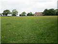
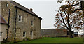
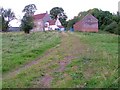
This page details the photographs taken nearby to TS9 7EU by members of the Geograph project.
The Geograph project started in 2005 with the aim of publishing, organising and preserving representative images for every square kilometre of Great Britain, Ireland and the Isle of Man.

There are currently over 7.5m images from over14,400 individuals and you can help contribute to the project by visiting https://www.geograph.org.uk
Image Map
Images are licensed for reuse under creativecommons.org/licenses/by-sa/2.0
Notes
- Clicking on the map will re-center to the selected point.
- The higher the marker number, the further away the image location is from the centre of the postcode.
Image Listing (4 Images Found)
Images are licensed for reuse under creativecommons.org/licenses/by-sa/2.0
Image
Details
Distance
3
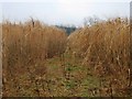
Elephant Grass at Meynell Hall
This photograph shows the route of the public footpath that passes through the field of 'elephant grass' near Meynell Hall. Also known as Miscanthus, this plant is used as a bio-fuel. The picture was taken looking in an east-north-easterly direction towards Meynell Hall. For a 'greener' version of this plant, see here: Image .
Image: © Philip Barker
Taken: 24 Jan 2010
0.17 miles