IMAGES TAKEN NEAR TO
Station Road, MIDDLESBROUGH, TS9 7AA
Introduction
This page details the photographs taken nearby to Station Road, TS9 7AA by members of the Geograph project.
The Geograph project started in 2005 with the aim of publishing, organising and preserving representative images for every square kilometre of Great Britain, Ireland and the Isle of Man.

There are currently over 7.5m images from over14,400 individuals and you can help contribute to the project by visiting https://www.geograph.org.uk
Image Map
Images are licensed for reuse under creativecommons.org/licenses/by-sa/2.0
Notes
- Clicking on the map will re-center to the selected point.
- The higher the marker number, the further away the image location is from the centre of the postcode.
Image Listing (3 Images Found)
Images are licensed for reuse under creativecommons.org/licenses/by-sa/2.0
Image
Details
Distance
1
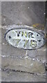
Old Bridge Marker on Station Road, Stokesley
County Bridge Marker on the parapet of Kirby Bridge over Eller Beck, on the east side of Station Road. Stokesley parish.
Milestone Society National ID: YN_STOKES01br
Image: © Mike Rayner
Taken: 7 Feb 2023
0.10 miles
2
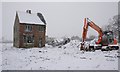
Former Plant Shop
There has been for years just past the school on the Helmsley Road what could very loosely be called a garden centre. The old character that ran it, Dicky Shore, never threw anything away and when his cottage became full he moved into a caravan and when that became full he moved into his landrover. He steadfastly resisted all attempts by the council to tidy the place up. One snowy morning I was surprised to see that the site had been cleared of all trees, shrubs and sheds. It had been completely overgrown. Although his caravan remained. Fearing the cottage might be demolished I thought I'd better take a photo for prosperity so I ventured out into the snow storm.
Dicky Shore died in April 2008 just three months after this photo was taken. For a newspaper report of his funeral which contains further details of this once familiar Stokesley character see the Grid Square Discussion http://www.geograph.org.uk/discuss/index.php?&action=vthread&forum=5&topic=7670&dontcount=1&page=0#1
Oct 08 Update: Now demolished!
Image: © Mick Garratt
Taken: 3 Jan 2008
0.22 miles
3
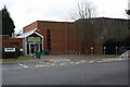
Stokesley Leisure Centre
This photograph shows a view of Stokesley Leisure Centre and Swimming Pool. The building is located between the A172 and B1365 roads near the roundabout that forms the junction between them. The picture was taken looking in a south-easterly direction towards Cleveland Nurseries.
Image: © Philip Barker
Taken: 12 Feb 2010
0.24 miles