
IMAGES TAKEN NEAR TO
Pannierman Lane, MIDDLESBROUGH, TS9 6PP
Introduction
This page details the photographs taken nearby to Pannierman Lane, TS9 6PP by members of the Geograph project.
The Geograph project started in 2005 with the aim of publishing, organising and preserving representative images for every square kilometre of Great Britain, Ireland and the Isle of Man.

There are currently over 7.5m images from over14,400 individuals and you can help contribute to the project by visiting https://www.geograph.org.uk
Image Map
Images are licensed for reuse under creativecommons.org/licenses/by-sa/2.0
Notes
- Clicking on the map will re-center to the selected point.
- The higher the marker number, the further away the image location is from the centre of the postcode.
Image Listing (12 Images Found)
Images are licensed for reuse under creativecommons.org/licenses/by-sa/2.0
Image
Details
Distance
1
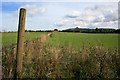
Field Near Greenhow Moor
Looking towards the conical hill of Roseberry Topping (in NZ5712). In the Great Ayton Enclosure Award of 1658 this was part of a large common pasture called West Moor. This particular bit was part of 59 acres awarded to George Marwood Esq.
Image: © Mick Garratt
Taken: 22 Sep 2007
0.07 miles

3

Cook's View Nursery
Formed in 1987, Cook's View Nursery supplies bespoke hanging baskets and other products.
Image: © Christine Johnstone
Taken: 1 Feb 2011
0.11 miles
4
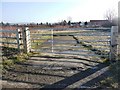
Gated wasteland west of new roundabout
Was this once the route of the road to Nunthorpe Hall?
Image: © Christine Johnstone
Taken: 1 Feb 2011
0.14 miles
5
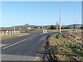
New roundabout
Traffic now has to slow down for the junction of the A172 and B1292.
Image: © Christine Johnstone
Taken: 1 Feb 2011
0.15 miles
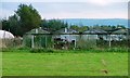
7

A172/B1292 Junction
For many years an accident black spot. A right turn for travellers from Great Ayton heading to Middlesbrough onto the busy A172. The day after this photo was taken, after much petitioning by the Great Ayton Parish Council, work was due to start on an island.
Image: © Mick Garratt
Taken: 30 Aug 2008
0.16 miles
8

Stokesley Soft Fruit Fruiteer
Stokesley Soft Fruit Fruiteer located on what used to be the old Pannierman Lane?
Image: © Rob Pollard
Taken: 7 Jul 2005
0.18 miles
9
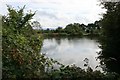
Pond Hear Greenhow Moor
Used by the Yarm Angling Club.
Image: © Mick Garratt
Taken: 22 Sep 2007
0.18 miles
10

Ash tree in winter
No mistaking those clumps of hanging seeds.
Image: © Christine Johnstone
Taken: 1 Feb 2011
0.18 miles