IMAGES TAKEN NEAR TO
High Street, MIDDLESBROUGH, TS9 6NH
Introduction
This page details the photographs taken nearby to High Street, TS9 6NH by members of the Geograph project.
The Geograph project started in 2005 with the aim of publishing, organising and preserving representative images for every square kilometre of Great Britain, Ireland and the Isle of Man.

There are currently over 7.5m images from over14,400 individuals and you can help contribute to the project by visiting https://www.geograph.org.uk
Image Map
Images are licensed for reuse under creativecommons.org/licenses/by-sa/2.0
Notes
- Clicking on the map will re-center to the selected point.
- The higher the marker number, the further away the image location is from the centre of the postcode.
Image Listing (128 Images Found)
Images are licensed for reuse under creativecommons.org/licenses/by-sa/2.0
Image
Details
Distance

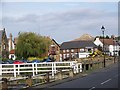
3

Great Ayton Bridge
Another drizzly misty morning so came back through the village. Ayton’s bridge over the River Leven was built in 1909 replacing an earlier humpbacked one. There has been a lot of rain overnight and the river is high. But I really wanted to photograph Easby Lane. That’s it, a residential road heading off in the distance, although the Post Office says first few houses are on Bridge Street. Easby Lane heads out the village climbing Halfpenny Hill, attaining a grand height of about ten metres. It is said Halfpenny Hill was named after a woman was found hanging there with only a halfpenny in her pocket.
But it is another tragedy I want to relate. On this day, October 20th, 1925, Oliver Jackson, a 68-year-old boot and shoemaker, was out having an evening stroll with a friend along Easby Lane, then a country lane, when a hare ran out of a field in front of them. Perhaps momentarily transported back to their childhood days the two men became so excited at the prospect of a chase but unable to compete with the hare they threw their walking sticks at it. In doing so Jackson overbalanced and fell in front of a passing motor-car fracturing his skull. He died at his home within two hours from compression of the brain. An interesting insight into the speed of the proceedings at that time, the inquest took place the next day at the Buck Hotel and was reported the same day in the Middlesbrough Evening Gazette carrying the headline “Unusual Fatality at Great Ayton”.
From my photo-diary for 20th October 2019 see http://www.fhithich.uk/?p=21801
Image: © Mick Garratt
Taken: 20 Oct 2019
0.02 miles
4

War Memorial
The WW2 inscription on the memorial which can be seen in this picture by Trish Steel: Image
The memorial itself is 12 foot high and was made from a block of freestone by local sculptor and stone mason Arthur Pearson in his workshop in Park Square in the village. It was erected in 1920 with the stone coming from Dunhouse Quarry near Darlington. Inspiration for the design came from the Celtic cross of St. Martin on the Isle of Iona off the west coast of Scotland.
Image: © Mick Garratt
Taken: 12 Oct 2008
0.02 miles
5
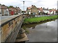
Street Scene, Great Ayton
Great Ayton takes its name from Ea-tun the tun or farm on an 'ea' or river. The village is overlooked by Roseberry Topping. Roseberry Topping is the most prominent and well-known natural landmark in Cleveland and it has its fair share of folk-tales associated with it.
Image: © Maigheach-gheal
Taken: 18 Oct 2007
0.02 miles
6
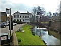
The Stone Bridge
Carrying the A173 through the village, bridge was built in 1909 replacing an earlier one dating from the late eighteenth century. The building reflected in the River Leven was formerly the Temperance Hotel. Opposite was Worthy Pearsons, the newsagents (first floor only visible above the bridge parapet).
Image: © Mick Garratt
Taken: 20 Oct 2007
0.03 miles
7
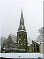
Christ Church
Built for a cost of £5,000 mostly raised by private donations and opened in 1877 to accommodate the growing population of Great Ayton. The old church being too small and in need of major repair Image The architects were Ross & Lamb, John Ross being an old boy of the Friends School.
Pevsner describes the church as of "a restless composition, and an uninteresting interior".
The modern structure to the right is the Parochial Hall.
Image: © Mick Garratt
Taken: 28 Dec 2005
0.03 miles
8
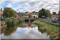
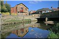
River Leven
Intended as a recreation of a photo dated 1955 by Francis Firth, see http://www.francisfrith.com/search/england/cleveland/great+ayton/photos/great+ayton_G112008.htm (for other examples see the forum thread http://www.geograph.org.uk/discuss/index.php?&action=vthread&forum=12&topic=3983&dontcount=1&page=0 ).
Very little has changed since 1955. Trees are more dominant but the buildings are structurally the same. There is now an absence of telegraph poles but more cars.
Image: © Mick Garratt
Taken: 12 Oct 2008
0.03 miles
9
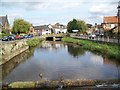
River Leven, Great Ayton
The River Leven running between High and Low Green. The village was the childhood home of the explorer Captain James Cook, who lived here between the ages of 8 to 16.
Image: © Maigheach-gheal
Taken: 18 Oct 2007
0.03 miles