IMAGES TAKEN NEAR TO
Hollygarth, MIDDLESBROUGH, TS9 6NG
Introduction
This page details the photographs taken nearby to Hollygarth, TS9 6NG by members of the Geograph project.
The Geograph project started in 2005 with the aim of publishing, organising and preserving representative images for every square kilometre of Great Britain, Ireland and the Isle of Man.

There are currently over 7.5m images from over14,400 individuals and you can help contribute to the project by visiting https://www.geograph.org.uk
Image Map
Images are licensed for reuse under creativecommons.org/licenses/by-sa/2.0
Notes
- Clicking on the map will re-center to the selected point.
- The higher the marker number, the further away the image location is from the centre of the postcode.
Image Listing (179 Images Found)
Images are licensed for reuse under creativecommons.org/licenses/by-sa/2.0
Image
Details
Distance
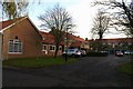
1
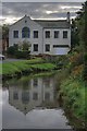
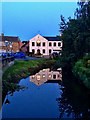
River Leven
Overlooked by the former eighteenth century Presbyterian chapel, now a private residence.
Image: © Mick Garratt
Taken: 12 Oct 2008
0.01 miles
2
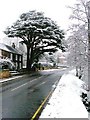
Great Ayton High Street
This large cedar tree has dominated the High Street for decades. The tree is in the grounds of Beech Grove, the home of Dr. William Augustus Loy, the village doctor in the late nineteenth century (the surgery being next door). The eastern end of the house (visible in the photo) is dated 1779. The western end is younger, built in the late nineteenth century. Cedar trees originated in the Lebanon and were introduced into this country in the late seventeenth century so this tree is considered to be as old the house.
Source: Great Ayton, A History of the Village by Dan o'Sullivan.
Image: © Mick Garratt
Taken: 28 Dec 2005
0.01 miles
3
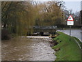
River Leven in spate at Great Ayton (view west)
This photograph shows unusually high levels of water in the River Leven as it flows through the village of Great Ayton. From here it flows in a westerly direction towards the village of Yarm. The road bridge to the west of the village centre can be seen in the centre of the picture.
Image: © Philip Barker
Taken: 6 Dec 2009
0.03 miles
4
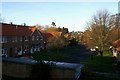
Sheltered housing in Holly Garth, Great Ayton
Sheltered housing in this part of Holly Garth is provided in two clusters of residences around a 'square' planted with trees, of which this is one. The stone building beyond is on High Street on the other side of the River Leven; the access bridge can just be seen. Another view of this housing scheme is at Image
Image: © Christopher Hall
Taken: 17 Dec 2013
0.03 miles
5
Sheltered Housing, Holly Garth, Great Ayton
A view of the other 'square' in this sheltered housing scheme looking in the opposite direction from Image
Image: © Christopher Hall
Taken: 17 Dec 2013
0.03 miles
6
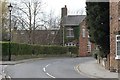
High Street
The unusually shaped building used to be Snowden's Smithy. Off to the left is Hollygarth.
Image: © Mick Garratt
Taken: 5 Apr 2008
0.03 miles
7
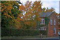
House on the High Street
An oddly shaped house sandwiched between the High Street and the River Leven. Built on the site of the former pinfold I believe.
Image: © Mick Garratt
Taken: 12 Oct 2008
0.03 miles
8
Seat Beside the River Leven
Several days of heavy rain has left the river full and fast, too fast for the village ducks. The ducks are well fed on bread from visitors. Every few years a cull is proposed, to much outrage.
Image: © Mick Garratt
Taken: 25 Jun 2007
0.04 miles
9
River Leven and the Hinmers Congregational Chapel
Image: © Mick Garratt
Taken: 2 Aug 2019
0.05 miles
10
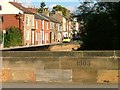
The Old High Street Viewed from Great Ayton Bridge
The road opposite used to be the main high street of Great Ayton before the High Green was developed. Notice the word "Ayton" has been cut out of the bridge parapet. This was done during the second world war to fox German paratroopers in case of an invasion.
Image: © Mick Garratt
Taken: 2 Oct 2005
0.06 miles