IMAGES TAKEN NEAR TO
High Street, MIDDLESBROUGH, TS9 6NE
Introduction
This page details the photographs taken nearby to High Street, TS9 6NE by members of the Geograph project.
The Geograph project started in 2005 with the aim of publishing, organising and preserving representative images for every square kilometre of Great Britain, Ireland and the Isle of Man.

There are currently over 7.5m images from over14,400 individuals and you can help contribute to the project by visiting https://www.geograph.org.uk
Image Map
Images are licensed for reuse under creativecommons.org/licenses/by-sa/2.0
Notes
- Clicking on the map will re-center to the selected point.
- The higher the marker number, the further away the image location is from the centre of the postcode.
Image Listing (155 Images Found)
Images are licensed for reuse under creativecommons.org/licenses/by-sa/2.0
Image
Details
Distance
1
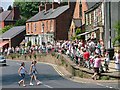
Suggitts, Great Ayton
Crowds line the raised pavement outside of Suggitts Cafe, famous for its ice cream, waiting for the Great Ayton procession to pass. The raised pavement was built to provide a dry passage for pedestrians when the river flooded.
Image: © Mick Garratt
Taken: 10 Jun 2006
0.02 miles
2
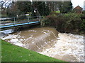
River Leven in spate at Great Ayton
This photograph shows an unusually high volume of water flowing underneath the bridges in Great Ayton near Suggitt's ice-cream shop.
Image: © Philip Barker
Taken: 6 Dec 2009
0.02 miles
3
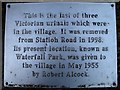
Plaque next preserved cast iron urinal, Great Ayton
Detail of the plaque next to the preserved cast iron urinal in waterfall Park shown in context in Image
Image: © Christopher Hall
Taken: 17 Dec 2013
0.02 miles
4
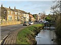
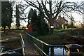
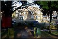
River and High Street, Great Ayton
The village centre here is attractive with the River Leven running alongside the main street.
Image: © Gordon Hatton
Taken: 1 Feb 2022
0.02 miles
5
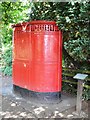
Victorian Cast Iron Urinal
The last survivor of three within the village. Grade II listed.
Image: © John M
Taken: 14 Aug 2013
0.02 miles
6
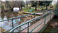
Footbridge across the River Leven
The footbridge across the River Leven was presented by George Whitbread, Under-manager at Ayton (ironstone) Mine in memory of miners lost during World War I. Beyond is a cast iron urinal moved into this area known as Waterfall Park, for preservation. The post and rail fence marks the line of a mill leat.
Image: © Christopher Hall
Taken: 17 Dec 2013
0.02 miles
7
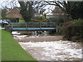
Bridges and water-drop in Great Ayton
This photograph shows the two bridges that cross the River Leven opposite Suggitt's shop in Great Ayton. The blue bridge is used by cars and the green bridge that lies behind it is a pedestrian footbridge. The water-drop can be seen just in front of the blue bridge.
Image: © Philip Barker
Taken: 6 Dec 2009
0.03 miles
8
Waterfall Bridge, Great Ayton
This footbridge over the River Leven into Waterfall Park is a war memorial. It was presented in 1919 by the Under-Manager of the Ayton Ironstone Mines, Mr. George Whitbread, and erected by the miners themselves, in memory of their five fellow workers who lost their lives in World War One:
Private Lawrence Johnson
Private Ernest Pearson
Robert Theobald
Private Arthur Wilks
Private Charles Wildman
Image: © Mick Garratt
Taken: 20 Mar 2016
0.03 miles
9
Waterfall Park, Great Ayton
Waterfall Park showing the cast iron urinal and George Whitbread bridge looking in roughly the opposite direct from Image
Image: © Christopher Hall
Taken: 17 Dec 2013
0.03 miles
10
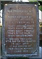
Detail of plaque on bridge over River Leven
Detail of the plaque on the bridge presented by George Whitworth in memory of miners who gave their lives during World War I. Note the correct (but not commonly used) date for the war of 1914-1919; 11 November 1914 was the armistice not the official end of the war. The bridge is shown in Image
Image: © Christopher Hall
Taken: 17 Dec 2013
0.03 miles