IMAGES TAKEN NEAR TO
Addison Road, MIDDLESBROUGH, TS9 6AW
Introduction
This page details the photographs taken nearby to Addison Road, TS9 6AW by members of the Geograph project.
The Geograph project started in 2005 with the aim of publishing, organising and preserving representative images for every square kilometre of Great Britain, Ireland and the Isle of Man.

There are currently over 7.5m images from over14,400 individuals and you can help contribute to the project by visiting https://www.geograph.org.uk
Image Map
Images are licensed for reuse under creativecommons.org/licenses/by-sa/2.0
Notes
- Clicking on the map will re-center to the selected point.
- The higher the marker number, the further away the image location is from the centre of the postcode.
Image Listing (154 Images Found)
Images are licensed for reuse under creativecommons.org/licenses/by-sa/2.0
Image
Details
Distance
2
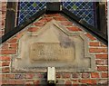
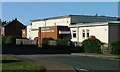
Date stone on the village hall, High Street
The stone indicates that this was the Village Club opened in 1915. The context of the building is shown in Image
Image: © Christopher Hall
Taken: 6 Feb 2014
0.08 miles
3
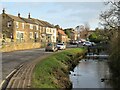
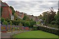
River and High Street, Great Ayton
The village centre here is attractive with the River Leven running alongside the main street.
Image: © Gordon Hatton
Taken: 1 Feb 2022
0.09 miles
4
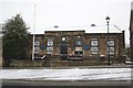
Public Library, High Street
Originally a school built in 1843 and funded by Quaker businessmen of Great Ayton, notably Thomas Richardson. It was known as the Ayton British School and had approximately 100 pupils between the ages of 5 and 14. The building has been a library since 1971.
Image: © Mick Garratt
Taken: 6 Apr 2008
0.09 miles
5
High Street
Intended as a recreation of a photo dated 1960 by Francis Firth, see http://www.francisfrith.com/search/england/cleveland/great+ayton/photos/great+ayton_G112012.htm (for other examples see the forum thread http://www.geograph.org.uk/discuss/index.php?&action=vthread&forum=12&topic=3983&dontcount=1&page=0 ).
Taken from the grounds of the Methodist Hall which has had handrails and paths improved for disabled access. The tree that occupied the front garden of the adjoining house in 1960 has since disappeared and the next building along, with the dormer windows in the roof has now been replaced by a building which is now a butchers. I seem to recall this was sometime a bank.
Image: © Mick Garratt
Taken: 12 Oct 2008
0.09 miles
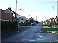
9
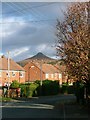
Capt. Cook's Way
The houses are on Capt. Cook's Way, in NZ5611. The photographer is on Linden Avenue, in NZ5510, the confluence of the northing and easting being close to the post box. In the background Roseberry Topping (in NZ5712) dominates.
Image: © Mick Garratt
Taken: 27 Nov 2006
0.09 miles
10
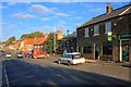
Waterfall Terrace
Intended as a recreation of a photo dated 1965 by Francis Frith, see http://www.francisfrith.com/search/england/cleveland/great+ayton/photos/great+ayton_G112027.htm (for other examples see the forum thread http://www.geograph.org.uk/discuss/index.php?&action=vthread&forum=12&topic=3983&dontcount=1&page=0 ).
Behind the white car is the former British School (Image]) although in 1965 it wasn't a library, the current use of the building. The cottages to its right now house an estate agent. In 1965 it looks as though they were residence. Previous occupancies included an health food shop. Immediately on the right is now Swans, a jewellers. This was formerly the Post Office which is now incorporated in the newsagents on Park Square.
Image: © Mick Garratt
Taken: 12 Oct 2008
0.09 miles