IMAGES TAKEN NEAR TO
Eagle Park, MIDDLESBROUGH, TS8 9QS
Introduction
This page details the photographs taken nearby to Eagle Park, TS8 9QS by members of the Geograph project.
The Geograph project started in 2005 with the aim of publishing, organising and preserving representative images for every square kilometre of Great Britain, Ireland and the Isle of Man.

There are currently over 7.5m images from over14,400 individuals and you can help contribute to the project by visiting https://www.geograph.org.uk
Image Map
Images are licensed for reuse under creativecommons.org/licenses/by-sa/2.0
Notes
- Clicking on the map will re-center to the selected point.
- The higher the marker number, the further away the image location is from the centre of the postcode.
Image Listing (3 Images Found)
Images are licensed for reuse under creativecommons.org/licenses/by-sa/2.0
Image
Details
Distance
2

Marton West Beck Trail
One of several steep sided wooded becks providing wildlife corridors into the heart of Middlesbrough.
Image: © Mick Garratt
Taken: 26 Mar 2009
0.16 miles
3
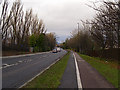
Dixon's Bank
The A172 road heading to Middlesbrough.
Image: © Stephen McCulloch
Taken: 27 Nov 2008
0.21 miles