IMAGES TAKEN NEAR TO
Peterson Place, TS8 9QH
Introduction
This page details the photographs taken nearby to Peterson Place, TS8 9QH by members of the Geograph project.
The Geograph project started in 2005 with the aim of publishing, organising and preserving representative images for every square kilometre of Great Britain, Ireland and the Isle of Man.

There are currently over 7.5m images from over14,400 individuals and you can help contribute to the project by visiting https://www.geograph.org.uk
Image Map (Loading...)


Getting Data...Please wait
Leaflet Map data © OpenStreetMap
Images are licensed for reuse under creativecommons.org/licenses/by-sa/2.0
Notes
- Clicking on the map will re-center to the selected point.
- The higher the marker number, the further away the image location is from the centre of the postcode.
Image Listing (4 Images Found)
Images are licensed for reuse under creativecommons.org/licenses/by-sa/2.0
Image
Details
Distance
1
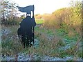
Viking Statue
A Viking warrior guarding the footpath to Tollesby. Denoting the Viking origin of this settlement.
Image: © Mick Garratt
Taken: 18 Nov 2005
0.11 miles
2
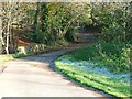
Slip Inn Bridge
Crossing Marton West Beck this section of Ladgate Lane is clearly shown on an 1771 map linking Yarm with Marske and is clearly much earlier but has now been bypassed and blocked off one end.
Image: © Mick Garratt
Taken: 18 Nov 2005
0.12 miles
4
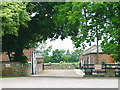
Newham Grange Farm
Newham Grange is an open community farm.
Image: © Mick Garratt
Taken: 26 May 2005
0.20 miles