IMAGES TAKEN NEAR TO
Austin Drive, MIDDLESBROUGH, TS8 9GR
Introduction
This page details the photographs taken nearby to Austin Drive, TS8 9GR by members of the Geograph project.
The Geograph project started in 2005 with the aim of publishing, organising and preserving representative images for every square kilometre of Great Britain, Ireland and the Isle of Man.

There are currently over 7.5m images from over14,400 individuals and you can help contribute to the project by visiting https://www.geograph.org.uk
Image Map
Images are licensed for reuse under creativecommons.org/licenses/by-sa/2.0
Notes
- Clicking on the map will re-center to the selected point.
- The higher the marker number, the further away the image location is from the centre of the postcode.
Image Listing (4 Images Found)
Images are licensed for reuse under creativecommons.org/licenses/by-sa/2.0
Image
Details
Distance
3
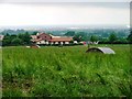
Larchfield Community
A land based residential community for adults with learning difficulties see http://www.camphill.org.uk/guide/larch/larch.htm. Fantastic bread.
Image: © Mick Garratt
Taken: 8 Jul 2005
0.22 miles
4
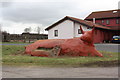
The Red Cow at Larchfield
This photograph shows a view of a red concrete cow sitting at the approach to the Larchfield Community buildings that are located just to the west of the B1365 road from Hemlington to Stokesley. The picture was taken looking in a westerly direction towards Thornton.
Image: © Philip Barker
Taken: 12 Feb 2010
0.23 miles