IMAGES TAKEN NEAR TO
Dunsmore Close, MIDDLESBROUGH, TS8 0BS
Introduction
This page details the photographs taken nearby to Dunsmore Close, TS8 0BS by members of the Geograph project.
The Geograph project started in 2005 with the aim of publishing, organising and preserving representative images for every square kilometre of Great Britain, Ireland and the Isle of Man.

There are currently over 7.5m images from over14,400 individuals and you can help contribute to the project by visiting https://www.geograph.org.uk
Image Map
Images are licensed for reuse under creativecommons.org/licenses/by-sa/2.0
Notes
- Clicking on the map will re-center to the selected point.
- The higher the marker number, the further away the image location is from the centre of the postcode.
Image Listing (9 Images Found)
Images are licensed for reuse under creativecommons.org/licenses/by-sa/2.0
Image
Details
Distance
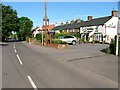
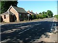
3
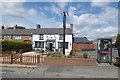
Chadwick's Inn, Maltby
Yes! At last, a pub open at lunchtime. Don't be fooled by the sky, soon it would be raining - for hours.
Image: © Richard Webb
Taken: 10 Aug 2016
0.11 miles
4
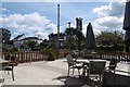
View from a pint
Looking over the road from a table outside Chadwick's Inn, Maltby.
Image: © Richard Webb
Taken: 10 Aug 2016
0.12 miles
5
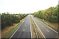
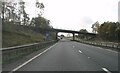
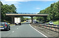
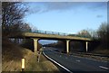
Traffic on the A19(T) road
This photograph shows a view of traffic on the A19(T) road near the bridge on Maltby Road. The picture was taken from the bridge looking in a north-easterly direction towards Acklam.
Image: © Philip Barker
Taken: 18 Sep 2010
0.12 miles