IMAGES TAKEN NEAR TO
Rosewood Court, MIDDLESBROUGH, TS7 8QS
Introduction
This page details the photographs taken nearby to Rosewood Court, TS7 8QS by members of the Geograph project.
The Geograph project started in 2005 with the aim of publishing, organising and preserving representative images for every square kilometre of Great Britain, Ireland and the Isle of Man.

There are currently over 7.5m images from over14,400 individuals and you can help contribute to the project by visiting https://www.geograph.org.uk
Image Map
Images are licensed for reuse under creativecommons.org/licenses/by-sa/2.0
Notes
- Clicking on the map will re-center to the selected point.
- The higher the marker number, the further away the image location is from the centre of the postcode.
Image Listing (18 Images Found)
Images are licensed for reuse under creativecommons.org/licenses/by-sa/2.0
Image
Details
Distance
2

Marton Library
Marton library offers a wide range of books and other resources for loan to the inhabitants of Marton. The library is located about 100 yards north-east of Marton's main shopping area (see here - Image) and the Marton Estate Square (see here - Image).
Image: © Philip Barker
Taken: 25 Nov 2009
0.14 miles
3
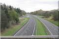
A174 Trunk Road at Marton (view east)
The A174(T) road runs from the Stockton area (in the west) towards Redcar (in the east). At peak periods this road carries substantial volumes of traffic pass and towards the village of Marton. This photograph was taken from the bridge at Marton (on the A172 road) looking in an easterly direction towards the coast at Redcar.
Image: © Philip Barker
Taken: 25 Nov 2009
0.14 miles
4
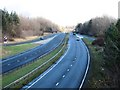
Exit Slip Road from west-bound A174 Trunk Road to A172 at Marton
This picture shows a van approaching the road junction at Marton interchange. The vehicle is probably going to turn right onto the A172 in the direction of Middlesbrough. The other lane takes traffic into Marton.
Image: © Philip Barker
Taken: 25 Nov 2009
0.16 miles
5
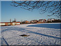
Snow in playing field - Captain Cook's School
This picture depicts a view of a snow-laden playing field at Captain Cook's School in Marton. The picture was taken on Christmas Day looking in a northerly direction towards Ormesby.
Image: © Philip Barker
Taken: 25 Dec 2009
0.17 miles
6
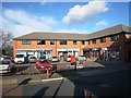
Marton Estate Square
This small shopping centre was recently built on land which was originally occupied by a petrol station. In some ways, it is just an extension of Marton's main shopping area (see here - Image). Marton Library is located about 100 yards to the right of this square (see here - Image).
Image: © Philip Barker
Taken: 25 Nov 2009
0.19 miles
7
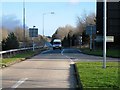
Traffic outside Captain Cook's School, Marton
The high volume of traffic that passes by Captain Cook's School (entrance through the green gates) makes crossing the road a very hazardous affair for school-goers.
Image: © Philip Barker
Taken: 25 Nov 2009
0.19 miles
8
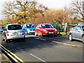
Deserted car park at Marton shops on Christmas Day (view NW)
During the day, a deserted car park is a very unusual sight at Marton shops. Christmas Day is probably the only day of the year when it is completely devoid of vehicular traffic. This photograph was taken looking in a north-westerly direction towards the Marton Country Club just before mid-day.
Image: © Philip Barker
Taken: 25 Dec 2009
0.19 miles
9

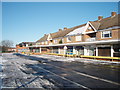
Traffic queue on Stokesley Road, Marton
At peak periods the traffic on Stokesley Road, Marton can be quite horrendous. Motorists and local residents who have to cope with it often refer to queues like the one shown above as the 'Marton crawl'.
Image: © Philip Barker
Taken: 25 Nov 2009
0.19 miles
10
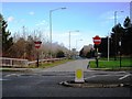
A174(T) - flow splitting of traffic on the exit slip road at Marton
The flow splitting arrangement shown here allows traffic from the west-bound carriageway of the A174 trunk road to split into two streams. At the junction, the north-bound flow (in the direction of Middlesbrough) can turn right onto the A172 road while the south-bound flow can merge left into traffic heading for Marton.
Image: © Philip Barker
Taken: 25 Nov 2009
0.21 miles