IMAGES TAKEN NEAR TO
Knaresborough Avenue, MIDDLESBROUGH, TS7 8LN
Introduction
This page details the photographs taken nearby to Knaresborough Avenue, TS7 8LN by members of the Geograph project.
The Geograph project started in 2005 with the aim of publishing, organising and preserving representative images for every square kilometre of Great Britain, Ireland and the Isle of Man.

There are currently over 7.5m images from over14,400 individuals and you can help contribute to the project by visiting https://www.geograph.org.uk
Image Map
Images are licensed for reuse under creativecommons.org/licenses/by-sa/2.0
Notes
- Clicking on the map will re-center to the selected point.
- The higher the marker number, the further away the image location is from the centre of the postcode.
Image Listing (7 Images Found)
Images are licensed for reuse under creativecommons.org/licenses/by-sa/2.0
Image
Details
Distance
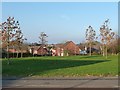
2
Houses in Rushmere, off Turnberry Way
Part of a new housing estate on the southern edge of Middlesbrough.
Image: © Christine Johnstone
Taken: 15 Nov 2018
0.19 miles
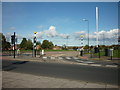
3
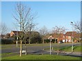
Open space at the junction of Turnberry Way and Fulwood Drive
Part of a new housing estate on the southern edge of Middlesbrough.
Image: © Christine Johnstone
Taken: 15 Nov 2018
0.21 miles
5
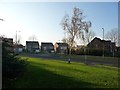
Houses in Evergreen Way, off Turnberry Way
Part of a new housing estate on the southern edge of Middlesbrough.
Image: © Christine Johnstone
Taken: 15 Nov 2018
0.23 miles