
IMAGES TAKEN NEAR TO
The Wickets, MIDDLESBROUGH, TS7 8EL
Introduction
This page details the photographs taken nearby to The Wickets, TS7 8EL by members of the Geograph project.
The Geograph project started in 2005 with the aim of publishing, organising and preserving representative images for every square kilometre of Great Britain, Ireland and the Isle of Man.

There are currently over 7.5m images from over14,400 individuals and you can help contribute to the project by visiting https://www.geograph.org.uk
Image Map
Images are licensed for reuse under creativecommons.org/licenses/by-sa/2.0
Notes
- Clicking on the map will re-center to the selected point.
- The higher the marker number, the further away the image location is from the centre of the postcode.
Image Listing (18 Images Found)
Images are licensed for reuse under creativecommons.org/licenses/by-sa/2.0
Image
Details
Distance
1
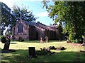
St. Cuthbert's Church, Marton
Capt. James Cook RN was christened in this church.
Image: © Mick Garratt
Taken: 17 Sep 2005
0.06 miles
2
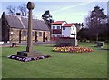
The Green, Marton Village
Green on the corner of Stokesley Road and The Grove.
The stone on the extreme right comes from Point Hicks Hill, near Cape Everard, Victoria which was the first point of land sighted on Australia's east coast during Captain Cook's first voyage of discovery.
Image: © Stephen McCulloch
Taken: 8 Apr 2007
0.06 miles
3
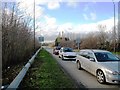
Exit Slip Road from east-bound A174 Trunk Road to A172 at Marton
This picture shows traffic on the exit slip road from the A174(T) waiting to turn right onto the A172 in order to travel towards Marton shops. Traffic using the other lane would turn left in the direction of Middlesbrough. Marton road bridge is just to the left of where this photograph was taken.
Image: © Philip Barker
Taken: 25 Nov 2009
0.07 miles
4
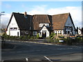
The Rudds Arms in 'Old' Marton
The Rudds Arms public house is located in the original village of Marton and is located in a convenient position just to the north of the A174(T) dual carriageway. The hostelry is located 'just across the road' from the Marton Country Club - see here: Image
Image: © Philip Barker
Taken: 25 Nov 2009
0.08 miles
5
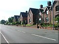
Row of Cottages, Stokesley Road
Built by Henry Bolckow in 1858 to rehouse the villagers of Marton who happen to live on the same spot where he wanted to build his new hall (see Image).
Image: © Mick Garratt
Taken: 17 Sep 2005
0.09 miles
6
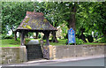
The Lych-Gate, St. Cuthbert's Church
Long lost relations of the photographer were parishioners here from 1875. Many years before then, navigator, James Cook was baptised in the Church.
http://www.g4fas.net/mmfsmary.html
Image: © Geoff Royle
Taken: 17 Jul 2008
0.10 miles
7
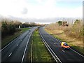
A174 Trunk Road at Marton (view west)
The A174(T) road runs from the Stockton area (in the west) towards Redcar (in the east). At peak periods this road carries substantial volumes of traffic pass and towards the village of Marton. This photograph was taken from the bridge at Marton (on the A172 road) looking in an westerly direction towards Stockton-on-Tees.
Image: © Philip Barker
Taken: 25 Nov 2009
0.10 miles
8
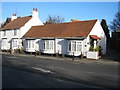
Cottages in 'Old' Marton
The cottages shown in this picture were located in the centre of the original village of Marton. Indeed, one of the cottages shown here used to be 'Marton Post Office'. The cottages look out onto the Rudds Arms public house (see here - Image) which lies just across the road.
Image: © Philip Barker
Taken: 25 Nov 2009
0.11 miles
9
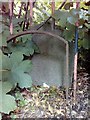
Old Boundary Marker
Municipal Boundary Marker on the east side of the A172 Stokesley Road, behind the boundary railings of Stewart Park. On the former boundary of Middlesbrough and Marton, now entirely in Middlesbrough unitary authority. Inscribed MIDDLESBROUGH / C.B. / 1932.
Milestone Society National ID: YN_MBRO01pb
Image: © A Cairns
Taken: 7 Jun 2020
0.12 miles
10
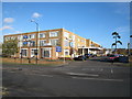
Marton Hotel and Country Club
The Marton Hotel and Country Club occupies a prominent position at the junction of two busy roads. The A172 (shown here) runs in a 'north-south' direction into and from Middlesbrough; the A174(T) runs in an 'east-west' direction from Stockton-on-Tees towards Redcar. The location of the hotel provides convenient access both to Middlesbrough and the North York Moors.
Image: © Philip Barker
Taken: 25 Nov 2009
0.13 miles