IMAGES TAKEN NEAR TO
Roseland Crescent, MIDDLESBROUGH, TS7 8AH
Introduction
This page details the photographs taken nearby to Roseland Crescent, TS7 8AH by members of the Geograph project.
The Geograph project started in 2005 with the aim of publishing, organising and preserving representative images for every square kilometre of Great Britain, Ireland and the Isle of Man.

There are currently over 7.5m images from over14,400 individuals and you can help contribute to the project by visiting https://www.geograph.org.uk
Image Map
Images are licensed for reuse under creativecommons.org/licenses/by-sa/2.0
Notes
- Clicking on the map will re-center to the selected point.
- The higher the marker number, the further away the image location is from the centre of the postcode.
Image Listing (5 Images Found)
Images are licensed for reuse under creativecommons.org/licenses/by-sa/2.0
Image
Details
Distance
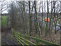
1
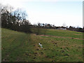
Footpath leading to The Grove
From Ormesby Grange farm. The houses are on Roseland Crescent.
Image: © Stephen McCulloch
Taken: 5 Feb 2008
0.05 miles
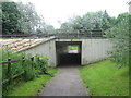
4
Railway bridge
The footpath between Ormesby Grove farm and The Grove runs under the Middlesbrough to Whitby railway line here.
Image: © Stephen McCulloch
Taken: 5 Feb 2008
0.13 miles
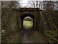
5
Footpath by the side of The Parkway
Leading to Ormesby Grange farm
Image: © Stephen McCulloch
Taken: 5 Feb 2008
0.20 miles