IMAGES TAKEN NEAR TO
The Grove, MIDDLESBROUGH, TS7 8AF
Introduction
This page details the photographs taken nearby to The Grove, TS7 8AF by members of the Geograph project.
The Geograph project started in 2005 with the aim of publishing, organising and preserving representative images for every square kilometre of Great Britain, Ireland and the Isle of Man.

There are currently over 7.5m images from over14,400 individuals and you can help contribute to the project by visiting https://www.geograph.org.uk
Image Map
Images are licensed for reuse under creativecommons.org/licenses/by-sa/2.0
Notes
- Clicking on the map will re-center to the selected point.
- The higher the marker number, the further away the image location is from the centre of the postcode.
Image Listing (9 Images Found)
Images are licensed for reuse under creativecommons.org/licenses/by-sa/2.0
Image
Details
Distance
4
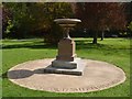
Captain James Cook Birthplace Memorial Urn
James Cook was born in a cottage in what was then the run down village of High Marton.
Image: © John M
Taken: 16 Aug 2013
0.20 miles
5
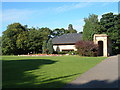
Captain Cook's Birthplace Museum
in Stewarts Park, Marton
Image: © Alison Stamp
Taken: 20 Aug 2005
0.20 miles
6

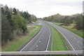
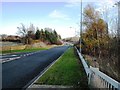
A174 Trunk Road at Marton (view east)
The A174(T) road runs from the Stockton area (in the west) towards Redcar (in the east). At peak periods this road carries substantial volumes of traffic pass and towards the village of Marton. This photograph was taken from the bridge at Marton (on the A172 road) looking in an easterly direction towards the coast at Redcar.
Image: © Philip Barker
Taken: 25 Nov 2009
0.21 miles
7
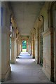
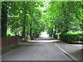
The Colonnade
A look along one of the few remains of Marton Hall built by Teesside industrialist Henry Bolckow in 1858 and destroyed by fire in 1960. In 1878 the estate passed to Bolckow's nephew Carl who managed to continue to lead an extravagant lifestyle despite the boom years of the iron industry being over. By 1907 the hall was empty, all fixtures being sold to pay off his debts. Apart from the billeting of troops during WW1 it was never lived in again. The estate was brought in 1925 by Thomas J Stewart who presented it to Middlesbrough as a park.
Image: © Mick Garratt
Taken: 17 Sep 2008
0.21 miles
8
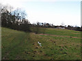
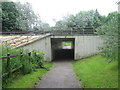
Footpath leading to The Grove
From Ormesby Grange farm. The houses are on Roseland Crescent.
Image: © Stephen McCulloch
Taken: 5 Feb 2008
0.23 miles
9
Entry slip road from A172 onto east-bound A174(T)
The slip road shown in this picture runs along-side the Marton Country Club which lies just to the left of where the above photograph was taken. This entry point to the east-bound A174(T) road allows traffic to travel in the direction of Redcar.
Image: © Philip Barker
Taken: 25 Nov 2009
0.24 miles