IMAGES TAKEN NEAR TO
Ripon Way, MIDDLESBROUGH, TS6 9NE

Introduction

This page details the photographs taken nearby to Ripon Way, TS6 9NE by members of the Geograph project.

The Geograph project started in 2005 with the aim of publishing, organising and preserving representative images for every square kilometre of Great Britain, Ireland and the Isle of Man.

There are currently over 7.5m images from over14,400 individuals and you can help contribute to the project by visiting https://www.geograph.org.uk

Image Map


Images are licensed for reuse under creativecommons.org/licenses/by-sa/2.0
Notes
  • Clicking on the map will re-center to the selected point.
  • The higher the marker number, the further away the image location is from the centre of the postcode.

Image Listing (19 Images Found)

Images are licensed for reuse under creativecommons.org/licenses/by-sa/2.0
Image
Details
Distance
1
Durham Drive - Winston Road
Image: © Betty Longbottom Taken: 26 Jul 2017
0.13 miles
2
Lodge Road - Winston Drive
Image: © Betty Longbottom Taken: 26 Jul 2017
0.16 miles
3
Service station on High Street
Image: © JThomas Taken: 25 Jan 2014
0.17 miles
4
Winston Drive - High Street
Image: © Betty Longbottom Taken: 26 Jul 2017
0.18 miles
5
Ironstone obelisks
These obelisks used to be sited at the entrance to Eston Hospital, which was built to serve the local mines and iron works. They were removed when the hospital was closed in 1980. They have since been returned to the old hospital site, which is now a small park.
Image: © Stephen McCulloch Taken: 1 May 2009
0.18 miles
6
The Miners Arms pub
High Street, Eston.
Image: © JThomas Taken: 25 Jan 2014
0.19 miles
7
Police station on High Street
Image: © JThomas Taken: 25 Jan 2014
0.20 miles
8
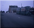
Two Buses in High Street, Eston
Taken in July 1970, this photo shows two vehicles in the short lived livery of Teesside Municipal Transport, which existed from the 1st April 1968 to 31st March 1974. Previously, they were owned by the Tees-side Railless Traction Board and painted in the Board's dark green and cream livery. The front vehicle is 37 (FVN 37D) a Leyland Titan motorbus with Roe 61-seater bodywork working to North Ormesby via Grangetown, whilst the one behind it is a Sunbeam F4 trolleybus 4 (GAJ 14) with similar bodywork working on a private tour of the area's trolleybus system which closed nine months later in April 1971. The trolleybus overhead wiring seen in this photo was soon dismantled after that closure. Behind the two vehicles in High Street is the Eston Constitutional WMC with the clock fixed to it, whilst in the distance to the left of the photo is Eston Congregational Church.
Image: © David Hillas Taken: 18 Jul 1970
0.20 miles
9
William Street - High Street
Image: © Betty Longbottom Taken: 26 Jul 2017
0.21 miles
10
The Foundry - High Street
Image: © Betty Longbottom Taken: 26 Jul 2017
0.21 miles