IMAGES TAKEN NEAR TO
Lastingham Avenue, MIDDLESBROUGH, TS6 9DG
Introduction
This page details the photographs taken nearby to Lastingham Avenue, TS6 9DG by members of the Geograph project.
The Geograph project started in 2005 with the aim of publishing, organising and preserving representative images for every square kilometre of Great Britain, Ireland and the Isle of Man.

There are currently over 7.5m images from over14,400 individuals and you can help contribute to the project by visiting https://www.geograph.org.uk
Image Map
Images are licensed for reuse under creativecommons.org/licenses/by-sa/2.0
Notes
- Clicking on the map will re-center to the selected point.
- The higher the marker number, the further away the image location is from the centre of the postcode.
Image Listing (10 Images Found)
Images are licensed for reuse under creativecommons.org/licenses/by-sa/2.0
Image
Details
Distance
5
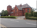
Christ Church, Eston - High Street
Image: © Betty Longbottom
Taken: 26 Jul 2017
0.19 miles
6
Eston & Normanby Cemetery
This is the approximate original site of St Helen's Church before, following extensive vandalism, it was demolished and rebuilt in Beamish Museum Image
Image: © Graham Hogg
Taken: 26 Mar 2018
0.19 miles
8
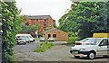
Site of former Eston station
View roughly SW: ex-NER terminus of a short branch from Flats Lane near Cargo Fleet, which had a passenger service only until 11/3/29, but was a goods terminal until 3/10/66. There was no sign of railway property in 1997.
Image: © Ben Brooksbank
Taken: 24 Jun 1997
0.21 miles
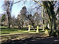
9
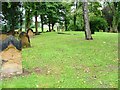
Eston Cemetery
The foundations that can be seen just beyond the tree are those of St. Helens Church. The church was 12th century but it is believed the site was originally a Roman garrison chapel. The name Eston itself is derived from the Saxon "Astune" for an ash tree which is traditionally associated with St. Helen.
Image: © Mick Garratt
Taken: 15 Sep 2005
0.23 miles
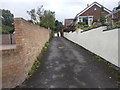
10
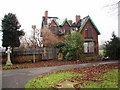
Eston Cemetery and East Lodge
This photograph shows a view of the fire-damaged East Lodge at Eston Cemetery. The picture was taken looking in a north-easterly direction towards the A1053 road (Greystone Road). More photographs can be seen here: http://www.pattinson.co.uk/Public/content/Buy/Estate-Agents/Property-For-Sale/109763.htm
Image: © Philip Barker
Taken: 6 Feb 2010
0.24 miles