IMAGES TAKEN NEAR TO
Carlyle Road, MIDDLESBROUGH, TS6 9AT
Introduction
This page details the photographs taken nearby to Carlyle Road, TS6 9AT by members of the Geograph project.
The Geograph project started in 2005 with the aim of publishing, organising and preserving representative images for every square kilometre of Great Britain, Ireland and the Isle of Man.

There are currently over 7.5m images from over14,400 individuals and you can help contribute to the project by visiting https://www.geograph.org.uk
Image Map
Images are licensed for reuse under creativecommons.org/licenses/by-sa/2.0
Notes
- Clicking on the map will re-center to the selected point.
- The higher the marker number, the further away the image location is from the centre of the postcode.
Image Listing (6 Images Found)
Images are licensed for reuse under creativecommons.org/licenses/by-sa/2.0
Image
Details
Distance
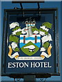
1
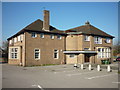
The Eston Hotel, Eston
A Sam Smith's public house.
Image: © Ian S
Taken: 22 Oct 2011
0.12 miles
2
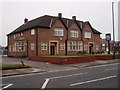
The Eston Hotel
This photograph shows a view of the Eston Hotel, Fabian Road, Eston, TS6 9BB. The picture was taken from the opposite side of the road looking in a southerly direction towards Eston cemetery.
Image: © Philip Barker
Taken: 6 Feb 2010
0.13 miles
3
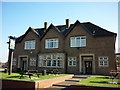
The Eston Hotel, Eston
A Sam Smith's public house.
Image: © Ian S
Taken: 22 Oct 2011
0.13 miles
4
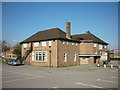
The Eston Hotel, Eston
A Sam Smith's public house.
Image: © Ian S
Taken: 22 Oct 2011
0.13 miles
5
The Eston Hotel, Eston
A Sam Smith's public house.
Image: © Ian S
Taken: 22 Oct 2011
0.13 miles
6
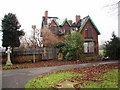
Eston Cemetery and East Lodge
This photograph shows a view of the fire-damaged East Lodge at Eston Cemetery. The picture was taken looking in a north-easterly direction towards the A1053 road (Greystone Road). More photographs can be seen here: http://www.pattinson.co.uk/Public/content/Buy/Estate-Agents/Property-For-Sale/109763.htm
Image: © Philip Barker
Taken: 6 Feb 2010
0.18 miles