IMAGES TAKEN NEAR TO
Hutton Road, MIDDLESBROUGH, TS6 8DB
Introduction
This page details the photographs taken nearby to Hutton Road, TS6 8DB by members of the Geograph project.
The Geograph project started in 2005 with the aim of publishing, organising and preserving representative images for every square kilometre of Great Britain, Ireland and the Isle of Man.

There are currently over 7.5m images from over14,400 individuals and you can help contribute to the project by visiting https://www.geograph.org.uk
Image Map
Images are licensed for reuse under creativecommons.org/licenses/by-sa/2.0
Notes
- Clicking on the map will re-center to the selected point.
- The higher the marker number, the further away the image location is from the centre of the postcode.
Image Listing (7 Images Found)
Images are licensed for reuse under creativecommons.org/licenses/by-sa/2.0
Image
Details
Distance
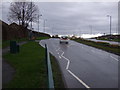
1
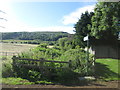
Start of the footpath to Eston Beacon
Fortunately, the path (only slightly less overgrown) runs beside the high wooden fence
Image: © John Slater
Taken: 3 Jul 2016
0.06 miles
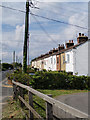
4
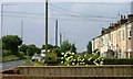
Fronts of Terrace, Crow Lane, Lackenby
Image: © Mick Garratt
Taken: 28 Jun 2006
0.14 miles
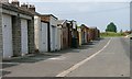
6
South Lackenby
Terrace of miners' cottages
Image: © Stephen McCulloch
Taken: 1 May 2009
0.16 miles
7

Old Hall Farm
Farm near South Lackenby
Image: © Stephen McCulloch
Taken: 1 May 2009
0.22 miles